Showing posts with label Rain. Show all posts

December 14, 2011

Wintry Mix & Strong To Damaging Winds Possible


Alerts:
CPV Weather
         -Champlain Valley Weather has issued a High Wind Watch for the Champlain Valley of Vermont, and New York for potential of strong to damaging winds of 25-40MPH with gusts 55-60MPH. The Watch is in effect from 11PM tonight until 6PM Thursday.

         -Champlain Valley Weather has issued a Winter Weather Advisory for the Northern Adirondack mountains in Northern New York, and much of Vermont, except the Champlain Valley and Western Rutland County for a Wintry mix of precipitation, with up to two tenths of an inch of ice accumulation. The Advisory is in effect from 10PM this evening until 10AM Thursday morning.

--------------------------------------------------------------------------------

National Weather Service:
         -The National Weather Service in Burlington, VT has not issued any alerts at this time.

         -The National Weather Service in Albany, NY has issued a Winter Weather Advisory for Bennington, and Windham Counties in Southern VT for wintry mix, and light glaze of ice. The Advisory is in effect from 10PM tonight until 6AM Thursday.

--------------------------------------------------------------------------------


Champlain Valley Weather Discussion:
         A significant storm system to impact the region later tonight into tomorrow, as a low pressure system strengthens from the Great Lakes region up into Canada. At this point it appears that the onset of precipitation will occur tonight resulting in cool temperatures to start, and light snow and/ or sleet should start nearly everywhere. The wintry precipitation will rapidly change over to rain though in the Champlain, and St. Lawrence Valleys, but the higher elevations, and especially the sheltered valley's will see the wintry precipitation last the longest, where it will change over to a period of freezing rain. Some of the most sheltered valley's in the Advisory area could see light freezing rain last until around 10AM tomorrow morning. This will result in up to 1 inch of snow, and up to two tenths of an inch of ice by 10AM tomorrow morning.

         As the strengthening storm system moves northeast from the Great Lakes, and into Canada a strong low level jet will develop resulting in strong southerly winds across the area. Nearly everyone will see wind gusts over 30MPH, however strong winds will occur in the St. Lawrence Valley and potentially damaging winds will occur in the Champlain Valley. At this point it appears the St. Lawrence Valley will see winds of 15-25MPH with gusts 45-50MPH. The same winds are likely in the Southern Champlain Valley as well. Across the Central, and especially Northern Champlain Valley though, winds will likely be stronger, and potentially damaging. Winds are expected to be in the 25-40MPH range with gusts 50 to 60MPH. The strongest winds will likely be closest to the lake shore, and over Grand Isle County. Over the open waters of Lake Champlain winds will be even stronger in the 40-50MPH range with gusts up to 65MPH. This will result in large battering waves on the open waters of Lake Champlain. There is still some question as to whether or not any rain will stabilize the surface layer and prevent the winds from mixing down to the surface, so at this point a High Wind Watch is in effect. It does appear likely that High Wind Warnings, and Wind Advisories will likely be issued later tonight, once a little more weather model data becomes available. Stay tuned for updates on this developing weather situation.

December 11, 2010

Another Storm Storm System To Impact The Region Sunday Into Monday


Alerts:
CPV Weather:
         -Champlain Valley Weather has issued a High Wind Warning for the Western slopes of the Green mountains in Vermont for winds in the 20-40MPH range with gusts ranging from 65-75MPH, especially in favored areas such as Richford, Bakersfield, Cambridge, Jericho, Huninton, and Rutland.

         -Champlain Valley Weather has issued a High Wind Warning for the Northern Adirondack Mountains in New York for winds in the 15-35MPH range with gusts ranging from 55-65MPH. All Warnings are in effect from 8AM Sunday morning until 8PM Sunday night.

         -Champlain Valley Weather has issued a Wind Advisory for the Champlain Valley, and Western Rutland County in Vermont for winds in the 15-25MPH range with gusts in the 45-55MPH range. The Highest gusts will occur across areas closes to the Western slopes of the Green mountains.

--------------------------------------------------------------------------------

NWS Burlington, VT:
         -The National Weather Service in Burlington, VT has issued a High Wind Watch for the Western Slopes of the Green mountains, and Western Rutland County for winds in the 20-35MPH range with gusts up to 60MPH.

         -The National Weather Service in Burlington, VT has issued a High Wind Watch for the Northern Adirondack Mountains in New York, for winds in the 20-30MPH range with gusts up to 55MPH. The watches are in effect from Sunday Morning through Sunday Night.

--------------------------------------------------------------------------------

NWS Albany, NY:
         -The National Weather Service in Albany, NY has issued a High Wind Watch for Bennington, and Western Windham Counties in Vermont for winds in the 20-40MPH range with gusts in the 50-60MPH range. The Watch is in effect from Sunday Morning through Monday Morning.

--------------------------------------------------------------------------------


Champlain Valley Weather Discussion:

OVERVIEW
         Low pressure over the Great Lake region will continue to move Northeast towards the St. Lawrence River Valley. A new low pressure system is expected to form near North Carolina, and move Northward over Western Vermont. This will result in primarily strong winds and rain.

WIND
         Winds will be the primary concern with this storm, especially along the Western slopes of the Green mountains. At this point winds shouldn't be quite as strong as they were on the Dec. 1st storm, but still gusts in excess of 65MPH is likely across the favored downslope areas. Isolated gusts to 75MPH could be possible. Max wind gusts in the Dec. 1st storm were in the 80-90MPH range, so this time around it will be damaging but not quite as bad. Conditions will continue to be monitored closely.

PRECIPITATION
         This system will start of with a mix of Snow/Sleet/Freezing Rain, and change over to all rain Sunday afternoon. Precipitation will change back to some snow by late Monday. By then most of the precipitation will be out of the region. Rain totals will range from a half inch in downslope areas to around 1 inch in the favored upslope areas. No flooding is expected. Stay tuned for further updates on this developing storm system.

November 17, 2010

Strong Winds To Impact The Region Overnight


Alerts:
CPV Weather
         -Champlain Valley Weather has issued a Wind Advisory for all of Northern New York, and All of Vermont for sustained winds of 15-30MPH, with gusts in the 40-50MPH range.

--------------------------------------------------------------------------------

NWS Burlington, VT
         -The National Weather Service in Burlington, VT has issued a Wind Advisory for all of Northern New York, and all of Vermont for sustained winds in the 20-35MPH range with gusts in the 46-50MPH range.

--------------------------------------------------------------------------------

NWS Albany, NY
         -The National Weather Service in Albany, NY has issued a Wind Advisory for Bennington, and Windham Counties in Southern Vermont for sustained winds in the 20-30MPH range with gusts up to 50MPH.

--------------------------------------------------------------------------------

Champlain Valley Weather Discussion:

OVERVIEW
         Low pressure currently North of the region is slowly strengthening resulting in a tight pressure gradient. The low pressure system should continue to move East-Northeast, and continue to bring strong winds to the region.

WIND
         The primary concern with the system is the wind. Much of the steady rain has moved North and East of the region with just some scattered showers left for this evening and overnight. A tight pressure gradient across our region is resulting in these strong winds. The winds will continue to strengthen this evening, and reach there peak overnight. Sustained winds will range from 15-30MPH with gusts in the 40-50MPH range. The highest gusts should be across the downslope areas of the Eastern slopes of the Adirondack mountains, and across the Southern Green mountains of Vermont. Winds of this magnitude have the potential to bring down weak trees, and tree limbs, resulting in scattered power outages.

PRECIPITATION
         The precipitation has pretty much ended with this storm. Some showers will be possible as winds turn to the Northwest and push any additional moisture into the mountains. The heaviest of showers will be combined to the Northwest upslope regions. A change from rain showers to snow showers is likely overnight. There is a slight chance of some snow flakes in the Champlain Valley if enough moisture is present by the time the temperatures drop. Stay tuned to Champlain Valley Weather for any further updates on this storm.

October 14, 2010

Major East Coast Storm To Bring Rain, Wind & Snow To Our Region


Alerts:
CPV Weather
         -Champlain Valley Weather has issued a Winter Weather Advisory for elevations of 1500 feet and higher in Orleans, Lamoille, Washington, Eastern Franklin, Eastern Chittenden, Eastern Addison, and Eastern Rutland Counties in Vermont, and Western Essex, Western Clinton, and Southern Franklin Counties in Northern New York for the potential of 2-6 inches of heavy wet snow.

         -Champlain Valley Weather has issued a Flood Watch for all of Vermont, and most of Northern New York, excluding St. Lawrence County for 1-3 inches of rain. Where the Winter Weather Advisory is in effect, the flood watch is in effect for those same counties, but primarily below 1500 feet, where mainly rain will fall.

         -Champlain Valley weather has issued a High Wind Watch for the Champlain Valley, and Rutland, and Bennington Counties in Vermont for the potential of strong to damaging winds. Sustained Northerly winds of 20-35MPH with localized gusts to 60MPH are possible, especially within the Champlain Valley, or on the South shore of Lake Champlain.

         -Champlain Valley Weather has issued A Wind Advisory is in effect for all the remainder of Vermont, and all of Northern New York for strong winds. Sustained Northerly winds will be in the 15-30MPH range with gusts to 50MPH.

--------------------------------------------------------------------------------
NWS Burlington, VT
         -The National Weather Service in Burlington, VT has issued a Flood Watch for portions of Northeastern New York, and For the all of Vermont excluding Grand Isle County, for the potential of 1-2 inches of rain, with localized amounts of up to 3 inches by Saturday.

--------------------------------------------------------------------------------
NWS Albany, NY
         -The National Weather Service in Albany, NY has issued a Flood Watch for Bennington, and Windham Counties in Vermont for the potential of 1-2 inches of rain with localized amounts of up to 3 inches.

         -The National Weather Service in Albany, NY has issued a Winter Storm Watch for elevations above 2000 feet, in Bennington, and Western Windham Counties in Vermont for the potential of 7 or more inches of snow by Saturday morning.

         -The National Weather Service in Albany, NY has issued a Wind Advisory for Bennington, and Windham Counties in Vermont for the potential of strong wind gusts up to 50MPH.

--------------------------------------------------------------------------------

Champlain Valley Weather Discussion:

OVERVIEW
         A strong, and dynamical storm is going to impact the region overnight tonight into early Saturday morning. A little bit of everything is expected with this storm, including heavy rain, strong winds, and heavy snow for elevations above 1500 feet.
         Currently a 1006mb low pressure system is located east of the delmarva peninsula, and moving Northeast. As this system continues to move Northeast it will rapidly intensify. Already 3hr pressure falls indicate its deepening at 3mb's in a 3 hour period, so 1mb an hour. Thats pretty decent, however later tonight and tomorrow, even more rapid intensification is likely. All models are in agreement bringing this storm down into the 980-984mb range, which is a very strong system.

RAINFALL
         Rain should continue to develop across the region overnight tonight, and become heavy at times after midnight. Rain will continue heavy at times across much of Vermont, for friday. There could also be some enhanced heavy rainfall for an extended period of time over the Champlain Valley, as significant Champlain Valley Convergence sets up, with a strong northerly flow. Rain totals across the entire area should range from 1-3 inches, some localized amounts near 4 inches is not completely out of the question at this time. The least amount of rain will be across the St. Lawrence Valley of New York, and the heaviest should be along the spine of the Green mountains. If the heavier amounts are witnessed then flooding will likely be an issue. Right now though only minor/ nuisance flooding is possible. The ground is still fairly saturated from the rains we had in late September.

WIND
         The wind concern is a bit more difficult to forecast with high confidence as many factors are pushing towards strong winds, but a couple strong factors are against it. First off as this system rapidly intensifies the pressure gradient is going to tighten fast. Winds just above the surface will be howling at 40-60 knots, however cool rain, and cool temperatures at the surface may help prevent winds from mixing down to the surface. Now, with this in mind we have another factor to look at, which is the direction of the wind. The wind is expected to be coming from the north, and with the Champlain Valley, being a North-South oriented Valley, means that a South or North wind is funneled through the valley making winds stronger. So it may not take much mixing down of the wind to the surface for it to become gusty, especially in the Champlain Valley. Thats why I have issued a High Wind Watch for the Champlain Valley, and Rutland and Bennington Counties, as Winds could be into the 20-35MPH range with isolated gusts to 60MPH, especially the closer to the lakeshore you get. If this become more immenent then a High Wind Warning may be needed, if the winds appear to be lighter then a Wind Advisory will be issued instead. And just that, a Wind Advisory is what in effect for the rest of the region as winds should mix down enough everywhere for gusts to occasionaly reach 50MPH, especially across exposed terrain.

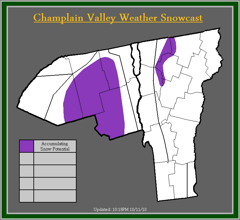
SNOWFALL
         This is going to be the most difficult part of the storm to predict. There is so much against it, and so much for it happening. First off the time of year is not the greatest to get significant snowfall across the area, but yes it does happen, especially in the higher elevations. Models dont agree at all on this situation, some models are showing absolutly no snow, and other are showing 6-12, and some are showing up to 20 inches of snow (for the highest of elevations of course)!!! Now due to the fact of this rapidly intensifing low pressure system being off the coast, and a 500mb cutoff overhead or very close by, the dynamical cooling alone should be absolutly impressive, and even with some models showing snow down to 2500 feet, I feel that the pure dynamics of this storm are going to give us some suprises, and I will side closer with the NAM model as far as where areas of snow are likely. I dont agree on how much the NAM model is showing however, so I have cut back significantly on the snow amounts on that model. I feel that 2-6 inches is strongly possible for areas above 1500 feet, with the lower amounts being near 1500 feet, and the higher amounts being towards the highest summits, and this is why I issued a Winter Weather Advisory for certain counties. In all honesty, I would not be surpised if some places above 3500 feet (which there is not many of) see snow totals around 10 inches. I wouldnt be suprised to see some wet snowflakes mix in even below 1500 feet, in fact I personally dont feel its out of the question for areas in the Valley away from lake Champlain to see some wet snowflakes mix in with the rain late friday evening/ night into Saturday morning. The reasoning behind that, once again is the strong north wind causing significant convergence in the valley resulting in the potential of some very dynamically heavy rain, which could push some cooler air even closer to the surface than currently expected. One thing I will say, is that absolutly no accumulation will occur in the Valley if some snowflakes were to mix in. It would still be primarily rain, and this would only occur for a very brief period of time. Stay tuned for further updates on this developing situation.

October 11, 2010

Potential Winter Weather Event Thursday To Saturday


Champlain Valley Weather Discussion:
         Suprisingly, models are coming into agreement on what could be out first semi-winter weather event. Models are showing a low pressure system forming along the mid-Atlantic coast, intensifying and moving up the coast to around Cape cod. This is where models diverge, some track it inland over southern and Central New England, others trend it over Cape Cod, and some models move the low pressure system to the east of Cape Cod. Also all models vary in strength. Some showing a sub 985mb low pressure system, while others show a sub 995mb, low pressure system. Neither is too shabby but the sub 985mb were to come true, we could be seeing an interesting scenario setting up.

         Currently I will play it middle of the road, and forecast mainly rain with some higher elevation snow showers especially in the Northern Adirondacks for the time being. The ultimate track and strength of this system is key to if, when, and how much snow will fall. At this point those living in elevations above 2000 feet should pay close attention to future forecasts. Those below 2000 feet, don't let your guard down quite yet, as those of us in Central and Northern Vermont, and Northeastern New York can easily remember the snowstorm back on April 28th of this year. I do want to urge that I am not saying this system is similar, but just remind those that the weather is very unpredictable. Also winds could be a factor with this upcoming storm system, stay tuned to Champlain Valley Weather for further updates on this potential situation.

September 7, 2010

Tropics Fairly Quiet For Now - Showers/ Thunderstorms Possible Overnight

Note: I would like to apologize for no further updates on Hurricane Earl. Luckily Erl just grazed the coast of North Carolina, and Virginia with low end Hurricane winds, and grazed southeastern New England with isolated Tropical Storm Winds.

   Champlain Valley Weather Discussion:
     Currently there is not too much to talk about tropics-wise, the only system around is Tropical Storm Hermine, which is well inland over Texas, and about to weaken to a remnant low over the next 12-24 hours. There is 3 areas over the open waters of the Atlantic that need to be monitored, but at this time no imminent development of these areas is likely. If any development occurs it will be slow.

     Now to talk locally, a cold front moving in from the great lakes region has already caused showers and some thunderstorms to fire up. In fact some of the storms are strong to severe, with some prompting a Severe Thunderstorm warning in far western New York at this time. Luckily though with the sun setting instability will wane, and these storms should weaken. By the time they make it to our area they should be mainly showers, with only isolated rumbles of thunder. The best chances for any thunder will be across western, and northern New York. Other than that, there is not much excitement in the weather for our area. Isolated showers will be the rule into early Friday, then clearing and cooler with highs in the upper 60's to lower 70's for Friday through Sunday.

February 23, 2010

Heavy Wet Snow Tonight Into Wednesday Night - Power Outages Possible


Alert Details:
         The National Weather Service in Burlington has issued a Winter Storm Warning for much of Vermont, and Northern New York for heavy wet snow accumulations of 12-18 inches in the Northern Adirondack Mountains, 8-14 inches across South Central Vermont, 4-10 inches across North Central and portions of Northeast Vermont, and 4-8 inches for the entire Champlain Valley. They have also issued a Winter Weather Advisory for portions of the St. Lawrence Valley and the far Northeast Kingdom for heavy wet accumulations of snow ranging from 2-6 inches.

         The National Weather Service in Albany, NY has issued a Winter Storm Warning for extreme southern Vermont for the potential of 8-16 inches of snow.

       & Champlain Valley Weather has issued a Winter Storm Warning for the Northern Adirondack Mountains, and portions of Central and Southern Vermont for 12-16 inches of snow with isolated amounts exceeding 16 inches across the highest of elevations, and favored upslope regions lower elevations in these areas will see 8-12 inches. A Winter Weather Advisory is in effect for the St. Lawrence Valley, the Champlain Valley, and much of Northern Vermont for 4-8 inches of heavy wet snow.

Champlain Valley Weather Discussion:
         Weather models are finally starting to agree somewhat upon a solution, especially for this first part of the storm. While small differences still remain, I feel confident enough to issue Winter Storm Warnings and Winter Weather Advisories for the area.

         I will admit I was having a hard time deciding whether or not to issue a Warning or Advisory for the areas receiving 4-8 inches. The reason being, this event is going to be around 24 hours long, and criteria to issue a Warning is 6 or more inches of snow within 12 hours or 8 or more inches of snow within 24 hours. Going strictly by that criteria an Advisory was issued, but I was contemplating the possibility of a Warning due to the fact the snow is going to be extremely wet and heavy, and has a good possibility of producing some power outages. At this time though I will hold off on a Warning, but I want you to be aware that the Advisory may be changed to a Warning depending on how this storm evolves. One more point I would like to make about this heavy wet snow, is all areas will have the potential for some power outages. Across the Warning area this will be even more important as the higher accumulations of very wet and heavy snow could cause some roof collapses, especially where 12 or more inches fall. Places that could experience roof collapses would be poorly constructed sheds or barns. With this storm it will be important to keep the snow cleared off your roofs.

         As for this portions of the long durations storm, you can expect a snow/ rain mix to develop across the region late this afternoon and spread from south to north. Snow will become heavy at times overnight tonight, and snowfall rates could reach 1-2 inches per hour for a time on Wednesday. Snowfall intensities like this will result in visibility under a half to quarter mile at times, and result in rapid accumulations. If you must travel tomorrow, use cautions and stay updated on this developing winter storm.

         Before I finish this post I am going to brush upon the next significant portions of this storm, which will be a low pressure system for Thursday into Friday night. This low pressure system will likely make this current system look small. This is because the next storm is not only going to effect a larger area of the Northeastern united states, but its going to have the potential to produce Blizzard conditions. A few models are indicating this potential such as the GFS which strengthens the low to 976mb over NYC, the RSM 976 over Albany, the NAM 980mb over NYC, and the WRF model 986mb over Rhode Island. That's just a few. The only thing with this, as the storm retrogrades back to the above mentioned areas at their above mentioned strength then this may cause warm air to push into our region, especially Northern areas. If that were to occur then more rain might be the result, also strong winds may cause significant shadowing across much of Northern Vermont. At this time though we will deal with the upcoming portions of this complex storm, and go from there. Stay tuned for further updates.

February 22, 2010

3 Part Storm System To Bring Significant Snow To The Region This Week


Champlain Valley Weather Discussion:
         Everything regarding the upcoming storm remains complicated, but with the first part of the storm set to move through Tuesday night into Wednesday night, I have had to make some decisions, although confidence is only moderate at this time.


Storm Part 1:
Tonight into Tuesday Afternoon...
         Light snow showers are expected to develop tonight with the first part of this storm system. This part of the storm is expected to remain fairly insignificant. Total snow accumulations from Tonight into Tuesday afternoon will range from T-1 inches in the Valley locations to 1-3 inches for the higher elevations.


Storm Part 2:
Tuesday Night into Wednesday Night...
         I have issued a Winter Storm Watch for the entire area, for Tuesday night into Wednesday night. Snow will increase in intensity overnight Tuesday and fall moderate to occasional heavy late afternoon Wednesday into Wednesday night before slowly lightening up. Snow totals by late Wednesday night will range from 6-10 inches for the Valley's and 10-15 inches for the higher elevations, and favored upslope regions, if temps happen to warm up then snow may mix with sleet or rain especially in valley locations and if this were to occur then valley locations may see significantly less then 6-10 inches of snow. Now if the precipitation remains all snow, then the snow will be wet and heavy with a 10:1 ratio likely, especially for the lower elevations. These amounts of wet and heavy snow will likely cause tress to be weighed down as well as power lines.


Storm Part 3:
Thursday into Friday Night...
         Light snow will be ongoing accumulating an additional 1-2 inches across the area before this next and likely most significant portion of the system takes over, in this time frame the most significant snowfall of the entire week will likely occur. A Winter storm watch may be required for this portions of the storm later in the week. Current indications suggest a low pressure system over the ocean will back towards new England and strengthen rapidly as it does so, this will result in significant amounts of moisture being thrown over our area. There is some question though as to how much warm air gets pulled in off the ocean and over our region. Current indications at this point though would lead to another 9-14 inches of snow region wide. Snow will tapper off overnight Friday night and only light snow showers will continue into Saturday night. The light snow showers will be capable of producing an additional 1-2 inches.

         Overall if these storm totals were to come to fruition, all together for the entire week snow totals would range from 14-25 inches in the Valley locations to 22-36 inches for the higher elevations. I would like to urge this is only on current forecasts, and confidence is only moderate at this time for the early stages of the storm, and then confidence decreases from there. This is an extremely difficult system to predict, especially with models not agreeing on a solution. Stay tuned for further updates.

January 25, 2010

UPDATE 4: Heavy Rain & Damaging Winds To Continue Today


Current Alert Details:
         The National Weather Service In Burlington, VT has issued a High Wind Warning for the Western Slopes of the Northern Green Mountains for Wind gusts up to 70MPH with locally higher gusts. A Flood Watch continues for much of Vermont, and portions of Northern New York, for the potential of Ice Jam flooding. A Wind Advisory has been issued for the Champlain Valley, and Updated for the Western slopes of the Central Green mountains in Vermont, and for the Adirondack mountains in Northern New York excluding the St. Lawrence Valley for winds in the 25-35MPH range with gusts 45-55MPH. A Wind Advisory has been issued for the remainder of Vermont for the potential of wind gusts in excess of 45MPH.

         The National Weather Service in Albany, NY continues a Flash Flood Watch for extreme Southern Vermont, for the potential of Flash flooding from heavy rainfall accumulations of 1-2 inches with local amounts nearing or exceeding 3 inches. As well as the potential for icejam flooding. A Wind Advisory remains in effect for extreme southern Vermont for strong wind gusts in the 45-55MPH range, with isolated higher gusts in the most favorable higher terrain.

         Champlain Valley Weather has updated the High Wind Warning for the Western Slopes of the Green mountains for sustained winds of 30-45MPH with gusts to 70MPH, localized gusts to 85MPH are possible in favored mountain gap locations of the Western slopes of the Green mountains. A High Wind Warning has been issued for the Vermont side of the Champlain Valley for sustained winds in the 25-40MPH range with gusts up to 55MPH. A Wind Advisory has been issued for the remainder of Vermont, and continues for Northern New York, excluding the St. Lawrence Valley for winds in the 15-30MPH range with gusts to 50MPH. The Flood Watch remains in effect for all of Vermont, and Northern New York for the potential of flooding of smaller creeks and streams, and the potential for Ice Jam flooding on many area waterways.

Champlain Valley Weather Discussion:
         Significant update to the forecast this afternoon. I have had to issue a High Wind Warning for the Vermont side of the Champlain Valley as winds have been very strong, and reports of power outages, trees down, and some minor structural damage have been received. Sustained winds on the Vermont side of the Champlain Valley have been ranging from 25-40MPH. Of even more concern is the fact the Western slopes of the green mountains have been seeing even greater winds then initially expected. A Wind gust of 82MPH was reported in Cambridge, Vermont at 10:43AM. Also in the town of Bakersfield, Vermont in Eastern Franklin County an older Barn was blow down. Thus I have updated the High Wind Warning for the Western slopes to include sustained winds of 30-45MPH with gusts to 70MPH, and isolated gusts to 85MPH. Also winds have increased across the remainder of the area with gusts ranging from 45-50MPH across the remainder of Vermont and Northern New York. Additional damage and power outages are likely this afternoon. Winds should begin to diminish around 3PM.

         As far as the rain is concerned, it has been able to hold out of Vermont for much of the day, due to significant downsloping/ drying winds. Rain has now begun to develop in ernest across Vermont, and the heavy rain is still likely to occur, it has just been delayed. This is not good either has sun was able to break out in many places and temperatures have warmer into the mid to upper 50's in many Valley locations, and mid 40's to lower 50's in the higher elevations. This has increased snowmelt, and already with not much rain, significant runoff is occur from the snowmelt alone. Conditions will continue to be monitored for any Flood Warnings or Advisories. Stay tuned for further updates on this serious weather event.

UPDATE 3: Heavy Rain & Strong Winds Today Into This Evening


Current Alert Details:
         The National Weather Service In Burlington, VT has continues a Flood Watch for much of Vermont, and portions of Northern New York, for the potential of Ice Jam flooding. A Wind Advisory remains in effect for the Western Slopes of the Green Mountains, and now for the Adirondack Mountains for wind in the 25-35MPH range with gusts up to 50MPH.

         The National Weather Service in Albany, NY continues a Flash Flood Watch for extreme Southern Vermont, for the potential of Flash flooding from heavy rainfall accumulations of 1-2 inches with local amounts nearing or exceeding 3 inches. As well as the potential for icejam flooding. A Wind Advisory remains in effect for extreme southern Vermont for strong wind gusts in the 45-55MPH range, with isolated higher gusts in the most favorable higher terrain.

         Champlain Valley Weather continues the Flood Watch for all of Vermont, and Northern New York for the potential of flooding of smaller creeks and streams, and the potential for Ice Jam flooding on many area waterways. A High Wind Warning remains in effect for the Western slopes of the Green mountains for winds in the 25-40MPH range with gusts up to 60MPH, localized gusts to 70MPH are possible in the most favored mountain gap locations. A Wind Advisory has been issued for Central, and Eastern Vermont, and portions of Northern New York for winds in the 15-30MPH range with gusts to 50MPH.

Champlain Valley Weather Discussion:
         Rain continues to push into the region from the west. Currently rainfall amounts across our region have ranged from around five hundreths of an inch to locally a quarter inch across portions of the St. Lawrence Valley. Rain will continue to become heavy at times today, and rainfall total remains pretty much unchanged. View the map above for the precipitation forecast.

         Significant rain, combined with snowmelt, and warm temperatures will result in rapid rises on areas waterways. This will result in a moderate risk of flooding, and a high risk of icejams, and their associated flooding.

         Winds will continue to increase today with localized gusts in the 70MPH range across the favored gap area of the Western slopes of the Green mountains. Although gusts in these areas will primarily be in the 55-60MPH range. Area across Central and Eastern Vermont, and portions of Northern New York will experience winds in the 15-30MPH range with gusts up to 50MPH.

         The threat for Wintry mix has winded down, only very isolated areas across eastern Vermont are seeing some freezing rain. This should only last another hour at the most, as strong winds will help raise temperatures across the entire region.

         Please stay tuned to Champlain Valley Weather, and your local media, and weather outlets for further updates on this storm system. Flood Warning, and Advisories may be needed later today. If you live near an area waterway, pay close attention to it, and at any signs of Flooding, evacuate immediately to higher ground. Another update is scheduled for later this afternoon.

January 24, 2010

UPDATE 2: Heavy Rain & Strong Winds Tonight Into Monday


Champlain Valley Weather Discussion:
         Just a quick update. Everything appears to be on track. I just wanted to re-issue the maps to reflect that Champlain Valley Weather has issued a Flood Watch to now cover all of Vermont and all of Northern New York. Previously the St. Lawrence Valley, and Grand Isle County of Vermont were not in the watch. Due to model trends, more rain is expected in the St. Lawrence Valley, enough so to expand the Flood Watch. While there is no major waterways in Grandisle County other then the broad lake, there is still small streams that could overflow, and not to mention localized street flooding is likely to occur due to clogged storm drains, so I have covered Grandisle county in the Watch now as well. Other then these minor changes everything else appears to be on track. Only brief freezing rain will occur in the Northern St. Lawrence Valley and Eastern Vermont, before temperature rapidly warm above freezing. The National Weather Service offices have made no changes to their official alerts at this time. Please view the previous post for full details on the storm, and stay tuned for further updates.

UPDATE: Heavy Rain & Strong Winds Tonight Into Monday


Current Alert Details:
         The National Weather Service in Burlington, VT continues a Flood Watch for much of Vermont, and portions of Northern New York for the potential of flooding from heavy rains, and the potential for ice jam flooding due to expected rapid rises on area waterways. They also have issued A Wind Advisory, which is in effect for the Western slopes of the Green mountains for Southeast winds of 25-35MPH with gusts up to 50MPH possible after midnight tonight.

         The National Weather Service in Albany, NY continues a Flash Flood Watch for extreme Southern Vermont for the potential of flash flooding due to heavy rains, and possible ice jam flooding due to significant rises on area waterways.

         Champlain Valley Weather continues a Flood Watch for much of Vermont, and portions of Northern New York for the potential of a widespread 1-2 inches of rain, with locally higher amounts, which will lead to potential flooding, and significant rises on area waterways, which will also produce great risk of ice jam flooding. A High Wind Warning now replaces the previous High Wind Watch, for the Western slopes of the Green mountains for the potential of strong southeast winds of 25-40MPH with gusts up to 60MPH, with isolated higher gusts in most favored mountain gap locations.


Champlain Valley Weather Discussion:
         A significant storm system, will begin to impact the region later this evening, with strong to potentially damaging winds, moderate to heavy rain, and potential flooding on Monday.

         Currently, a 984mb low pressure system over Northeastern Wisconsin, will continue to move North-Northeast today, and this evening. Out ahead of this system a strong, and moist southerly flow upon a tightening pressure gradient will continue to result in temperatures rising, moisture pushing into our area, and winds to increase.

         Heavy rain and the flood potential is the primary concern with this system. Rain will develop later this evening, and become heavy at times after midnight. Rain will continue heavy at times through Monday morning, and begin to diminish in intensity Monday afternoon. Rainfall totals are depicted on the map at the top of this post, so please make sure to check that out. The heaviest rain still appears to be across Central, and Southern Vermont. Its not out of the question for isolated amounts in excess of 3-4 inches to occur, especially across the Southeast upslope areas of the Central, and Southern Green mountains. This amount of rain combined with snowmelt, from temperatures being in the 40's to near 50 Monday, will result in rapid rises on area waterways.

         With the ground being frozen the rainfall, and snow melt will flow directly into area waterways, and not be absorbed by the ground at all, which is very significant. I was thinking about following the National Weather Service in Albany, NY and issue a Flash Flood Watch for everyone, but a large question remains as to how much the current snowpack will be able to absorb and hold the rain. In the Champlain, and St. Lawrence Valley's there is around 4-9 inches of snow. The snowpack across these places wont be able to absorb the rain as the snowpack is not that great. Across the higher terrain though especially about 1000 feet, snowpack of 12+ inches remains. These areas will be able to hold the rain better, but with warmer temperatures the past week or so, with slight melting everyday, and the expected warmer temperatures today, and Monday the snowpack may be ripe, and if it is, then rapid snowmelt will occur as well in the higher elevations. But its not knowing, which is holding me off from a Flash Flood Watch.

         Eitherway, rapid rises on area waterways will occur, and with the rivers rising, and a solid sheet of ice across them, this ice will become unstable and begin to break. This will result in a significant ice jam threat, and their associated flooding risks. So overall I feel a flood watch is the safe bet, and we will remain with that.

         Right now the pressure gradient is tight, but no where as tight as what it will be later tonight or tomorrow morning. Already we are seeing a primarily southerly wind, which is being enhanced in the Champlain Valley resulting in sustained winds in the 10-20MPH range, with gusts in the 25-35MPH range. Earlier a wind gust of 41MPH was recorded at the National Weather Service office in Burlington, Vermont. The 41MPH wind gust appears to be a more localized stronger gust, and remains shy of the 46MPH gust criteria for a Wind Advisory. These winds will continue to be monitored, but at this point I am not going to issue a Wind Advisory, and you will likely not see one issued for the National Weather Service for the Champlain Valley either.

         As the winds slowly shift to a more southeasterly direction things will become more interesting overnight, especially along the western slopes of the Green mountains, where the National Weather Service has issued a Wind Advisory. I feel winds are going to be stronger then anticipated and I have issued a High Wind Warning. I feel there will be a time period long enough for High Wind Warning type winds to occur before the heaviest rain moves in to stabilize the lower layer of the atmosphere. Even then I feel damaging wind gusts will be able to mix down and funnel through the favorable mountain gaps, and passes of the Western slopes of the Green mountains. Therefor in areas such as Richford, Bakersfield, Cambridge, Jericho, Huntington, Appalachian Gap, Rutland, and Bennington, winds will increase into the 25-40MPH range by late tonight, with gusts in the 60MPH range. Some of these gusts will be able to accelerate better through some of the mountain gaps, and isolated wind gusts to 70MPH are possible in the most favorable gap locations. The strongest winds should occur prior to the heaviest rainfall, but even after the heaviest rain moves in, isolated damaging wind gusts will likely continue, but be less often, and likely be well under 70MPH. The strong to damaging winds should start to diminish later Monday afternoon.

         The last concern is the potential for some light icing at the onset of precipitation tonight, especially across the sheltered valley's of eastern Vermont, and the extreme Northern St. Lawrence Valley of New York. The National Weather Service in Burlington has issued a Freezing Rain Advisory for the Northeast Kingdom and Eastern Vermont for the potential of up to a tenth inch of ice accumulation. I am holding off on issuing a Freezing rain advisory, while I feel the areas that receive ice accumulation in eastern Vermont will be very isolated. Also I feel if any area has a greater threat of seeing icing, it would be the extreme Northern St. Lawrence Valley, where winds remain out of the northeast, and the temperatures are still below freezing. The atmosphere is also very dry, and as the precipitation tries to fall through the atmosphere it will result in evaporative cooling, which will help lower temperatures a couple degrees area wide. So places currently hovering around freezing will likely fall below freezing, resulting in some sleet/ freezing rain. I will continue to monitor this potential, for the possibility of issuing a Freezing Rain Advisory for the Northern St. Lawrence Valley, and perhaps portions of eastern Vermont. Stay tuned to Champlain Valley Weather, and your locally weather and media outlets for further information on this upcoming storm system. I will try to have another update later this evening.

January 23, 2010

Flooding Rains & Strong Winds Possible For Sunday Into Monday


Champlain Valley Weather Discussion:
         The National Weather Service in Burlington, VT has issued a Flood Watch for much of Vermont, and portions of Northern New York for the potential of flooding from heavy rains, and the potential for ice jam flooding due to expected rapid rises on area waterways.

         The National Weather Service in Albany, NY has issued a Flash Flood Watch for extreme Southern Vermont for the potential of flash flooding due to heavy rains, and possible ice jam flooding due to significant rises on area waterways.

         Champlain Valley Weather has issued a Flood Watch for much of Vermont, and portions of Northern New York for the potential of 1-2 inches of rain with locally higher amounts, which will lead to potential flooding, and significant rises on area waterways, which will also produce great risk of ice jam flooding. A High Wind Watch has also been issued for the Western slopes of the Green mountains for the potential of strong southeast winds of 25-40MPH with gusts up to 60MPH, with isolated higher gusts in most favored mountain gap locations.

         Currently a low pressure system is expected to move into the Midwestern portion of the United States, and push significant amounts of moisture, and warmer air into the region.

         Rain showers should develop Sunday afternoon, and overspread the entire region by Sunday evening. Rain will become steady overnight, and become heavy at times through Monday afternoon. Widespread rainfall totals of 1-2 inches, with locally higher amounts to near 4 inches are possible by Monday afternoon. The highest amounts are likely to occur across Central, and Southern Vermont. This amount of rain combined with temperatures in the mid 40's to lower 50's, will produce significant snowmelt, and runoff into are waterways. The result will be significant rises on area waterways, and potential flooding. Along with normal flooding concerns, the rapid rises will likely break up river ice and result in ice jams, which could enhance flooding significantly. If you live near an area waterway, it is urged to monitor it closely, and at any signs of flooding, move to higher ground immediately.

         Rain wont be the only problem with this storm system, winds will also be a concern. Especially along the western slopes of the green mountains. Southeast winds across the entire region will average 15-25MPH with isolated gusts up to 40MPH. For the favored gap locations along the western slopes of the green mountains such as Cambridge, Huntington, and Rutland winds will likely be in the 25-40MPH range with gusts up to 60MPH, isolated gusts up to 70MPH are possible in the most favored mountain gap locations. Winds of this magnitude would result in tree damage, and power outages as well as isolated structural damage. The strongest winds will occur late Sunday Night into Monday afternoon. Stay tuned for further updates on this developing storm system.

November 27, 2009

UPDATE 2: Black Friday Nor'easter


Champlain Valley Weather Discussion:
         First and foremost I would like to wish everyone a happy thanksgiving, and I hope everyone's day went well. Those who have to travel home tomorrow maybe instore for some nasty weather.

         Currently radar shows an area of light to moderate rain stretching from central and western new york, down to the eastern half of North Carolina. Also radar is indicating rain rapidly developing over long island New York, spreading up into Southern New England. Also to mention 3 hour pressure falls off the Southern New England coast are impressive, showing that the pressure in that area is falling at a rate of 10 millibars every 3 hours. Or 3.33 millibars an hour!!!

         The low pressure center should continue to rapidly intensify and begin to move more north, and perhaps even north-northwest, and into the gulf of Maine by tomorrow. Rain should develop across our region between 5AM and 7AM. Rain will become steadier throughout the day Friday, and mix with snow towards evening at the lower elevations, and mix with snow by afternoon in the higher elevations. Things should change over to all snow overnight Friday, with all snow in the higher elevations by Friday evening. Total snow accumulations will range from a Trace to 3 inches in the Champlain Valley, and elevations below 800 feet, with 3-6 inches likely above 800 feet. Locally higher amounts of up to 8-10 inches is possible in areas such as Jay Peak, and Mt. Mansfield. Winds will also increase Friday afternoon into the 15-30MPH with gusts up to 50MPH, with higher elevations possibly seeing localized gusts up to 55MPH. Winds will gradually diminish by Saturday evening. With all of the above in mind, I have issued a Winter Weather Advisory for the Western Slopes of the Green mountains, and point east, for 3-6 inches of snow accumulations by Saturday afternoon. I have also issued a Wind advisory for the entire region for the above mentioned winds. I want to urge though, that this forecast is still very uncertain, and is highly dependent upon the final track and strength of the low pressure system. If things trend slightly colder then more snow may occur resulting in a Winter Storm Warning for the higher elevations, and perhaps a Winter Weather Advisory for the lower elevations. Also if the system strengthens a little more then currently predicted, then a High Wind Warning may be needed for the Western slopes of the green mountains and points east. At this time there is NO OFFICIAL ALERTS issued by the National Weather Service. Stay tuned for further updates.

November 20, 2009

Soaking Rain This Morning; Snow By Thanksgiving?

Champlain Valley Weather Discussion:
         Currently temperatures are fairly mild for a November night across the region, mainly due to the fact of clouds moving in before the sun had set, which has not allowed good radiational cooling. Rain is currently heaviest over northern New York, with heavy rain being reported in Watertown, and Saranac Lake, and moderate rain being reported in Potsdam, and Massena. For the most part the Champlain Valley, and points east are dry right now, with the exception of some showers moving across the extreme Northern Champlain Valley. The Swath of moderate to occasionally heavy rain will continue to slowly move east into the Champlain Valley and points east, as the upper level low pressure system over the Great Lakes region continues to slowly move to the Northeast.

         Total rainfall accumulations into tomorrow afternoon should range from .25" to .50" in the Champlain Valley with locally higher amounts to near .66" where the pockets of heavier rain exist. For areas east of the Champlain Valley to the New Hampshire border, can expect rainfall totals by tomorrow afternoon ranging from .33" to .75" with isolated amounts to .90". Along the immediate western slopes of the green mountains, some isolated lower rain totals of .10" to .20" could occur due to shadowing/ downsloping off the Green mountains, on a Southeasterly flow.

         Also with the Southeast flow, favored gap locations along the western slopes of the green mountains can also expect some isolated gusty winds, with sustained winds in the 10 to 20MPH range with isolated gusts to around 30MPH. Especially in areas such as Bennington, Cambridge, and Rutland. Infact as of the 1:00AM observations, Bennington was reporting sustained winds of 18MPH with gusts to 30MPH, and Rutland was reporting sustained winds of 14MPH with gusts to 21MPH. Winds for the rest of the area, including the Champlain Valley should remain in the Calm to 10MPH range with gusts up to 15MPH.

         Now time to talk about the pattern change coming up next week, including the possibility of some snow for Thanksgiving night or perhaps the day after.

         A series of small storms will help initiate the beging of the pattern change. The first in the series of systems is starting out across the Texas gulf coast right now, this system will move east, along the gulf coast states and then begin to head Northeast and up the east coast. This will bring some moderate to heavy rainfall to the south, and some moderate rain to the mid-atlantic region come Sunday night. Our region will possibly be effected by this system during the day Monday, with some light rain. Then a clipper system will move southeast out of Canada bringing some colder air with it for Wednesday into Thanksgiving day. It is then when things become more complicated. Some models are showing that thanksgiving night, into Friday night, some energy in the mid section of the country will round the base of the trough in the eastern United States, and a new low pressure system will try to form somewhere along the mid-atlantic coast, and intensify as it moves northeast. There are several major questions to whether or not this provides measurable snow...

1.) Will a coastal low pressure system actually form?
2.) Will enough cold air be in place by then to produce snow?
3.) How strong will the coastal low become, and where will it track?

         At this point unfortunately, these questions cant be answered with any type of certainty. The only question that can be moderately answered is whether or not a coastal low will form. The potential is there, as models have been fairly consistent with some type of low pressure system forming off the mid-Atlantic coast. But the other two questions which are key to whether we get snow or not, will have to await further model runs to be answered. Stay tuned!

November 14, 2009

Remnants Of Ida Still Being Difficult To Forecast

Champlain Valley Weather Discussion:
         Currently light to moderate rain continues from the Champlain Valley east, with some occasional heavy rain along the Western Slopes of the Green mountains up into the Northeast Kingdom. The rain has held together better then originally expected, and depicted by the weather models, and across the entire region, a fairly uniform area of .60" - 1.00" of rain has fallen, with locally higher amounts up to 1.25". Additional rainfall amounts will range from around a tenth inch in the Champlain Valley up to four tenths of an inch along the spine of the Green mountains up into the Northeast Kingdom. Rainfall totals will be in the 0.70" - 1.40" range, with isolated amounts up to 1.75", especially across North Central, and Northeastern Vermont.

         I had forgot to mention in the previous post (because the forecast appeared to be on track) but Ida, has actually been interesting to forecast. The models have not done overly well, right from the beginning of Ida's transition to an Extra-Tropical low pressure system. Models first indicated that Ida would move out to sea, and the heaviest rain never make it further North then the Carolina's. As each model run came in, it continued to edge it further and further north. The models did a decent job on rainfall amounts across the Carolina's and the Mid-Atlantic once the storm was upon them. For our region it appears as of 24 hours ago, that if we received a quarter of an inch here in the Champlain Valley, that would be on the high side, well things have changed significantly since 24 hours ago. Even this morning, the only model that really showed significant rainfall of an inch or more was the 06Z GFS model, which appeared to be an outlier. I guess it just goes to show, that the weather will do as it pleases, and not always can the scientifically rich computer models figure it out.

Below is a list of a few selected rainfall totals as of 7:40PM, from a variety of weather stations, including personal weather stations...

Vermont
Marlboro: 1.61"
Glover: 1.27"
Chester: 1.14"
Newport: 1.13"
St. Albans: 1.06"
Guilford: 1.04"
Swanton Village: 1.01"
Springfield: 0.95"
Montpelier: 0.93"
South Burlington (NWS Office): 0.78"
Rutland: 0.78"
Morrisville: 0.71"
Searsburg: 0.63"
Bennington: 0.37"

New York
Moriah: 1.08"
Ticonderoga: 0.98"
Ellenburg Depot: 0.93"
Plattsburgh: 0.84"

Remnants Of Ida Effecting The Region Today

Champlain Valley Weather Discussion:
         Currently light to moderate rain is falling across the entire region, infact some occasionally heavy rain has been noted in some areas. This rain is from the remnants of former Hurricane Ida, which made landfall in the US as a Tropical Storm. Ida then transitioned from a tropical system to an extra-tropical low pressure system and pounded the mid-Atlantic states, dropping up to a foot of rain, and strong damaging winds to hurricane force, 75MPH. The center of Ida's remnants is actually still well off the southeast coast of the United States, but her moisture continues to move North, and break away from the low pressure center.
         Rain will continue light to moderate at times today, with occasional heavier showers. Intensity of the precipitation should begin to diminish later this evening, and all but end by midnight. Total rainfall accumulations should range from a quarter to half inch in the Champlain Valley, with isolated amounts up to three quarters of an inch, to half to one inch across the Western slopes of the Green mountains and points east. Locally higher amounts could occur across Eastern and Southeastern Vermont. There should be no flooding issues, other then ponding of water on roadways in some of the heavier rain, and poor drainage areas.

October 17, 2009

UPDATE 2: Tonight-Tomorrow Storm

Champlain Valley Weather Discussion:
     Finally, just hours before the onset of precipitation, models come into somewhat better agreement. The GFS now keeps precipitation further Southeast, although it still brings snow into Central Vermont. One good thing about this, is the fact the snow that the GFS does bring into central Vermont, is showing it to be much lighter, and not likely to accumulate several inches. Infact, the thermal profile of the GFS is slightly warmer then previous runs. So as of now, there will be no alerts issued, and you can expect a rain/ snow mix tonight across Southern, and Central Vermont changing to all snow, even in the deeper valley's by very early Sunday morning, then changing back to a rain snow mix, and eventually to all rain by Sunday afternoon. Total snow accumulations will range from a Dusting to 2 inches in the deeper valley's to 1-3 inches in the higher elevations and 3-6 inches at summit levels. The heaviest snow will be confined to the summit levels, across Southeastern Vermont. Impacts should be minimal therefor no alerts are needed. I will keep a close eye as the storm continues to develop but at this time, it does appear much of the region will not be seeing any accumulating snow. Nevertheless stay tuned.

UPDATE: Saturday-Sunday Storm

Champlain Valley Weather Discussion:
     Its now officially Saturday (12:33AM), and even being this close to a potential storm system, the weather models continue to strongly disagree. The Operational GFS continues to be a Northwestern outlier, and the NAM, and Euro continue to hold the precipitation much further to the Southeast. The difficult problem with this is, the fact the GFS has proven to be quite accurate with the placement of the precipitation of the last storm, and the GFS has been very consistent with showing this scenario. But on the other hand the NAM, and Euro have also been consistent with there solution. Even with the majority of models leaning into the favor of the NAM, and Euro, the GFS just cant be ignored yet. Unfortunately this looks like it is going to be a "wait and see" type storm. Where the precipitation ends up is primarily in the hands of the trough placement, and low pressure center placement, and strength.

     Right now on water vapor imagery, you can see the trough is really starting to dig south, and steepen. Already there is an area of increased pressure falls across Southeastern New Jersey, and adjacent coastal waters. It will be interesting to see exactly where the low forms, its strength, and eventual track will be. Right now the potential still exists for around a dusting to 1 inch of snow in the Champlain Valley of Vermont, and several inches of snow for the higher elevations of Vermont, especially those across Central, Southern, and Eastern Vermont. That's if the GFS model verifies. I have not issued any "Suggested alerts". I will await another couple model runs before I make my decision, check back tomorrow afternoon for another update. Once again, I want to urge that if the GFS model is to verify, the POTENTIAL exists for several inches of heavy wet snow across portions of the region. Stay tuned for further updates.

October 16, 2009

Cold Temperatures To Continue; Snow Possible Saturday Into Sunday

Champlain Valley Weather Discussion:
     Things will get warmer, but not before another couple cold days, and some snow! Currently a Nor'easter that formed off the Delmarva Peninsula, earlier today is moving east-northeast, and away from the region. Snow continues though across Pennsylvania, Northwestern New Jersey, and the Southern tier of New York, and even into the hills to the west, and east of the Capital district of New York. Infact Winter Weather Advisories and Winter Storm Warnings are in effect for portions of the above mentioned regions. The heaviest snow is expected to occur over the higher elevations of Central/ North Central Pennsylvania, where up to 10 inches of snow could fall, by Saturday. Being October, this snow had an extremely high water content, and this heavy wet snow falling on foliaged trees, is resulting in limbs snapping. This is only with 1-4 inches of snow being reported so far, across Central Pennsylvania. If the heavier amounts of snow up to 10 or more inches occur, that could be locally devastating in that area, with significant tree damage, and power outages.

     Right now the northern edge of the snow has shifted slightly further north then expected, with light snow, snow/rain, and rain being reported along a ling from Niagara Falls, NY, to Geneva, NY, to near Bennington, VT. This is more inline with the GFS model, which has been called a Northern outlier for this, and the next storm. This is very interesting for the upcoming forecast which I will be talking about in a couple minutes. First lets talk temperatures.

     Right now across the Champlain Valley temperatures are in the mid to upper 20's. Temperatures have actually been rising over the past couple of hours, as winds slightly increase, and cloud cover moves in. Most locations in the Champlain Valley have hit lows in the mid 20's, prior to the temps rising. Currently its 29F degrees in Swanton Village, 28F degrees in Burlington, VT, 25F degrees in Berkshire, and Morrisville, VT, and 28F Degrees in Plattsbugh, NY.

     Now onto the talk about snow for Saturday. Right now, also of interest is the fact, precipitation is slightly more intense, and lasting longer then initially predicted across Pennsylvania, New Jersey, and New York. This area of precipitation should start to weaken in intensity, and should all but come to an end for these areas, by this afternoon. As an additional piece of energy starts to carve a trough, and form a new low pressure center off the Mid-Atlantic coast, precipitation will redevelop across the Mid-Atlantic states, Southern New York and Southern New England, by late Friday night or Early Saturday morning. This is when things become tricky, as models do not agree on a solution yet. The NAM has consistently keeping the precipitation of this next developing storm system across Southern New England, and the Mid-Atlantic States back into Central Pennsylvania. While the GFS as of 3 model runs ago shifted its precipitation further north from Central Pennsylvania, north and east into central, and eastern New York, and across Vermont, and New Hampshire. Once again the GFS model has been considered a northern outlier, but as of right now, that northern outlier is accurate. Will it be accurate for the next storm though is the big question, and the big dilemma. The Euro model keeps it south of our area like the NAM does, and the Canadian model is pretty much a mix between the NAM/ EURO, and the GFS. The Canadian model brings the precipitation into Central Pennsylvania, into Southeastern New York, into Central, Vermont, and New Hampshire. This will likely be a good model to use for now, but its hard to avoid the fact the GFS has been accurate so far, showing what the other models refuse to show. If the GFS solution were to come true, as its been showing over the past 3 model runs, then this would mean some snow for our area. With up to 1 inch in the Champlain Valley and 2-5 inches in the higher elevations, especially across Central, and Eastern Vermont. Across summit levels up to 8 or 9 inches of snow could fall if the GFS solution were true. Right now there are no official alerts issued for our area from the National Weather Service in Burlington, and they are not talking about issuing any either. But if the potential becomes imminent that 4 inches or more of this heavy wet snow will fall in the higher elevations, then I may issued a Winter Storm Watch on my "Suggested Alerts Map". Generally a Winter Storm Watch is issued for the potential of 6 inches or more of snow within 12 hours or 9 or more inches of snow within 24 hours. But due to the fact this could be a very heavy wet snow, I am using the Advisory Criteria level snow, of 4 inches to issue a Watch, and potential Warning. Once again this is ONLY if the GFS model begins to verify on this next storm for Saturday into Sunday. Right now, just stay tuned for the POTENTIAL of a few inches of heavy wet snow in the higher elevations.