Showing posts with label Update. Show all posts

December 14, 2011

UPDATE: Wintry Mix & Strong To Damaging Winds Tonight Into Tomorrow


Alerts:
CPV Weather
         -Champlain Valley Weather has issued a High Wind Warning for the Northeastern Champlain Valley of Vermont, for strong to damaging winds of 25-40MPH with gusts 55-60MPH. The Watch is in effect until 6PM Thursday.

         -Champlain Valley Weather has issued a Wind Advisory for all of Northern New York, and much of Vermont for sustained winds of 15-30MPH with gusts 40-50MPH. Isolated higher wind speeds are likely in the St. Lawrence and Champlain Valley's. The Advisory is in effect until 6PM Thursday.

         -Champlain Valley Weather continues a Winter Weather Advisory for eastern Vermont, for a Wintry mix of precipitation, with 1-2 inches of snow, and up to two tenths of an inch of ice accumulation. The Advisory is in effect until 10AM Thursday morning.

--------------------------------------------------------------------------------

National Weather Service:
         -The National Weather Service in Burlington, VT has not issued any alerts at this time.

         -The National Weather Service in Albany, NY has issued a Winter Weather Advisory for Bennington, and Windham Counties in Southern VT for wintry mix, and light glaze of ice. The Advisory is in effect until 6AM Thursday.

--------------------------------------------------------------------------------


Champlain Valley Weather Discussion:
         Storm system strengthening over the great lakes region will continue to move northeast and into Canada. A few adjustments were needed. The winter weather advisory for Northern New York, and the western slopes/ spine of the green mountains was cancelled, as temperatures near or above freezing will continue to rise, resulting in very little frozen or freezing precipitation. East of the spine of the green mountains though is a different story, cold air will hold on tough, in fact temps will likely fall a couple more degrees in the most sheltered Valley's. Thus a Winter Weather Advisory will continue here, as frozen/ freezing precipitation is likely to linger into tomorrow mid morning.

         The Wind aspect of this storm remains the most significant portion of this storm, especially for the Champlain Valley. The High Wind Watch was replaced with a High Wind Warning for the Northeast Champlain Valley, and a Wind Advisory for all of northern New York, and the rest of Vermont. Winds in the warning area will range from 25-40MPH with isolated gusts of 55-60MPH. On the open waters of Lake Champlain winds of 35-50MPH with occasional gusts to 60MPH are likely. For the remainder of the area, wind speeds will range from 15-30MPH with gusts 40-50MPH. The highest wind speeds, will be in the St. Lawrence, and Champlain Valley portion of the Advisory, and even isolated higher wind speeds could occur in those areas. Especially near the Lake Champlain shoreline. Stay tuned for further updates.

January 23, 2011

UPDATE: Arctic Airmass Over The Region


Alerts:
CPV Weather
         -Champlain Valley Weather continues the Wind Chill Warning for wind chills in the 25F to 35F below zero range in the Immediate central and southern Champlain Valley, with Wind chills of 35F to 55F below zero elsewhere, with the coldest readings across portions of the extreme Northern Adirondacks, and the Northeast Kingdom of Vermont. The Wind Chill Warning is in effect until 11AM Monday.

--------------------------------------------------------------------------------

National Weather Service Alerts:
         -The National Weather Service in Burlington, VT has issued a Wind Chill Advisory for all of Vermont, and Northern New York for wind chills as low as 25 below zero this evening. The Advisory is in effect until 10PM this evening.

-The National Weather Service in Albany, NY has issued a Wind Chill Warning for Bennington, and Windham Counties in Southern Vermont for wind chills of 30-40 degrees below zero. The Warning is in effect until 9AM Monday morning.

--------------------------------------------------------------------------------


Champlain Valley Weather Discussion:
OVERVIEW
         An arctic air mass has set up across the region, and will create the coldest temperatures of the season tonight.

TEMPERATURES
         Tonight will be the coldest night of this arctic blast, temperatures will range from 20F to 35F below zero area wide, with isolated areas in the Northeast Kingdom of VT, and the Northern Adirondacks of NY getting down into the 35F to 45F below zero range. For Monday temperatures will range from 5F below zero to 5F above zero area wide.

WIND CHILLS
         The temperatures above, combined with a persistent wind of 3-7MPH will result in life threatening wind chills. For tonight wind chills will be life threatening with wind chills ranging from -30F to -55F. Isolated areas in the Northeast Kingdom, and Northern Adirondack mountains could briefly reach wind chills of 55F to 65F below zero. For Monday wind chills will be from 0F to 20F below Zero.

PREPAREDNESS
         This is going to be an extremely dangerous situation. Temperatures, and wind chills this cold can cause frostbite in under 15 minutes. Death from hypothermia can occur much quicker in temperatures, and wind chills such as these. These cold temperatures have not been witnessed at the very latest, since mid January of 2009. With the country not seeing such widespread cold temperatures since 2007.

         It is extremely important to make sure your heating system is functioning properly, and make sure its cleaned. Also make sure Chimneys are cleaned, vents are clear of snow, and you have a working carbon monoxide and smoke detector in your home. For you Vehicle make sure to keep a full tank of gas to prevent your fuel lines from freezing, and make sure your vehicle is in top shape if planning to travel. When starting your vehicle make sure to let it run at the very least 30 minutes before driving as you can damage your vehicles engine. Also make sure to dress warmly, and in layers. Make sure to wear a heavy winter jacket if planning on venturing out doors. Make sure you have gloves or mittens, a hat and hood, and scarf or something to cover your face. For more tips on protecting yourself in extreme cold weather please visit the two links below.

National Weather Service Office, Burlington, VT. Public Information Statement On Arctic Blast

CDC Safety Tips On Extreme Cold Weather

January 18, 2011

UPDATE: Wintry Mix To Change To Snow Showers Overnight


Alerts:
CPV Weather
         -Champlain Valley Weather continues the Winter Storm Warning for portions of central and southern Vermont for 6-9 inches of snow, along with up to a quarter inch of ice accumulation across extreme Southern Vermont by Wednesday morning. The Warning is in effect until 7AM Wednesday morning.

         -Champlain Valley Weather has continued the Winter Weather Advisory for the entire Champlain Valley of Vermont, North Central Vermont, and the Northeast Kingdom, as well as Essex County New York for 3-6 inches of snow, along with up to a tenth of an inch of ice accumulation across central Vermont by Wednesday morning. The Advisory is in effect until 7AM Wednesday morning.

--------------------------------------------------------------------------------

National Weather Service Alerts:
         -The National Weather Service in Burlington VT, has issued a Winter Storm Warning for Rutland, Windsor, and Orange Counties in Vermont for 5-10 inches of snow by Wednesday morning. The Warning is in effect until 7AM Wednesday morning.

         -The National Weather Service in Burlington VT, has issued a Winter Weather Advisory for portions of Northern and Central Vermont, as well as Essex County New York for 2-6 inches of snow by Wednesday morning. The Advisory is in effect until 7AM Wednesday morning.

         -The National Weather Service in Albany NY, issued a Winter Storm Warning for Bennington, and Windham Counties in Vermont for 4-8 inches of snow, and up to two tenths of an inch of ice by Wednesday morning. The Warning is in effect until 7AM Wednesday morning.

--------------------------------------------------------------------------------


Champlain Valley Weather Discussion:

OVERVIEW
         Low pressure near Cape Cod will continue to move Northeast, and away from the region. A cold front moving in from the west, will bring in cooler temps and more light snow for tomorrow.

PRECIPITATION
         Well for the most part, things have gone fairly well. I did have to drop western Franklin County, VT from the Winter Weather Advisory, and downgrade the Warnings to Advisories across Western Addison, and Rutland Counties, as well as Caledonia County, as snow totals are not as high as expected. I did contemplate leaving the Warnings/ Advisories in place as an area of concentrated snow may continue across the Champlain Valley and western slopes of the green mountains as winds shift to the North and Northwest, and produce convergence, and upslope snows. Also another area of snow will develop across much of the region as a cold front and associated waves of low pressure ride up along the front, including isolated snow squalls, but with looking at all the pieces, the snow would occur over a fairly long period of time, not to mention the later is a completely separate system, so I decided adjusting the Warnings/ Advisories were an appropriate idea. Conditions will be monitored closely tomorrow morning though as Snow squalls are possible around the morning commute time frame.

January 12, 2011

UPDATE: Nor'easter Underway Across Our Region


Alerts:
CPV Weather
         -Champlain Valley Weather has continued the Winter Storm Warning for much of Vermont for 6-10 inches of snow across the northern portions of the Warning, to 10-18 inches across central Vermont to 18-24+ inches across South Central, and Southern Vermont, by this evening. The Warning is in effect until 5PM this evening.

         -Champlain Valley Weather has continued Winter Weather Advisory for far Northwestern, and North Central Vermont as well as much of Northern New York for 3-6 inches of snow with locally higher amounts across the Southern portions of the Advisory. The Advisory is in effect until 5PM this evening.

--------------------------------------------------------------------------------

National Weather Service Alerts:
         -The National Weather Service in Burlington VT, has issued a Winter Storm Warning for Orange, Windsor, and Rutland Counties in Vermont for 6-12 inches of snow by this evening.

         -The National Weather Service in Burlington VT, has issued a Winter Weather Advisory for much of Northern Vermont, and Essex County New York for 3-7 inches of snow by this evening.

         -The National Weather Service in Albany NY, has issued a Winter Storm Warning for Bennington, and Windham Counties in Vermont for 12-24 inches of snow with locally up to 30 inches of snow by this evening.

--------------------------------------------------------------------------------


Champlain Valley Weather Discussion:

OVERVIEW
         Stengthening Low Pressure near Cape Code will continue to strengthen and move northeast today, bringing heavy snow to much of the region.

SNOW
         Everything remains on track, just had to increase snow totals across Southern Vermont based on spotter reports and radar trends. Over 2 feet of snow is possible across the upslope regions of the Southern Green mountains, and across much of Windham county. It appears winds will pick up blowing this snow around causing some areas of significant drifting. But winds should remain below Blizzard Criteria.

         Snow will continue to spread all the way to the canadian border by later this morning. Snow will be going heavy across southern Vermont where snowfall rates as high as 4 inches per hour are possible. Across portions of Northern and central Vermont some heavy snowfall rates of 1-2 inches per hour are possible, and across parts of New York snowfall rates of a half to 1 inch per hour are possible for a brief time. There is a slight chance of Thundersnow across far Southern Vermont as intense mesoscale bands set up. Stay tuned for further updates.

January 11, 2011

MAJOR UPDATE: Nor'easter Tracks Further West


Alerts:
CPV Weather
         -Champlain Valley Weather has issued a Winter Storm Warning for much of Vermont for 6-10 inches of snow across the northern portions of the Warning, to 10-18 inches across south-central, and southern Vermont by Wednesday evening. The Warning is in effect from 2AM Wednesday until 5PM Wednesday.

         -Champlain Valley Weather has issued a Winter Weather Advisory for far Northwestern, and North Central Vermont as well as much of Northern New York for 3-6 inches of snow with locally higher amounts across the Southern portions of the Advisory. The Advisory is in effect from 3AM Wednesday until 5PM Wednesday.

--------------------------------------------------------------------------------

National Weather Service Alerts:
         -The National Weather Service in Burlington VT, has issued a Winter Storm Warning for Windsor, and Rutland Counties in Vermont for 5-9 inches of snow across Rutland County, and 6-12 inches of snow across Windsor County by Wednesday Evening.

         -The National Weather Service in Burlington VT, has issued a Winter Weather Advisory for Addison, Washington, Orange, and Caledonia Counties in Vermont for 3-5 inches with locally up to 7 inches by Wednesday evening.

         -The National Weather Service in Albany NY, has issued a Winter Storm Warning for Bennington, and Windham Counties in Vermont for 8-16 inches with locally 10-20 inches of snow by Wednesday Evening.

--------------------------------------------------------------------------------


Champlain Valley Weather Discussion:

OVERVIEW
         Two areas of energy are merging with a central low pressure system tracking up the east coast. This will result in snow further north.

SNOW
         The model which seems to be coming to fruition is the NAM model which has said this storm will track further west, and it has. I have expanded the Warning further North, and have issued an Advisory for much of Northern New York as well. Warning area will range from 6-10 inches North to 10-18 inches South. I am still being slightly conservative on the snow amounts to the North and West. The Advisory covers 3-6 inches with the highest amounts across the southern portions of the Advisory. If the storm continues to track further west, than an Advisory may eventually be needed for the St. Lawrence valley, but I will hold off for now.

         Snow should spread across much of the region by tomorrow morning. Snow will be going heavy across southern Vermont where snowfall rates as high as 4 inches per hour are possible. Across portions of Northern and central Vermont some heavy snowfall rates of 1-2 inches per hour are possible, and across parts of New York snowfall rates of a half to 1 inch per hour are possible for a brief time. Stay tuned for further updates on this developing storm system.

December 27, 2010

UPDATE: Spotter Reports From VT Require Warning Re-issuance


Alerts:
CPV Weather
         -Champlain Valley Weather has issued a Winter Storm Warning for Franklin, Chittenden, and Lamoille Counties in Vermont for storm total snowfall of 6-12 inches with isolated areas along the Western Slopes of the Warning area receiving 12+ inches of Snow. The Warning is in effect until 11PM this evening.

         -Champlain Valley Weather has issued a Winter Weather Advisory for the entire Champlain Valley, and all of Vermont for Blowing Snow, Cold Wind Chills, and Light Snow, with additional accumulations of a Trace to 3 inches. The Winter Weather Advisory is in effect until 11PM tonight.

--------------------------------------------------------------------------------

NWS Albany, NY:
         -The National Weather Service in Albany NY, has issued a Winter Weather Advisory for Bennington, and Windham Counties in Southern Vermont for Blowing Snow.

         -The National Weather Service in Albany, NY has issued a Wind Chill Advisory for Bennington and Western Windham County in Vermont for dangerous wind chills down to 20 below zero tonight.

--------------------------------------------------------------------------------


Champlain Valley Weather Discussion:

OVERVIEW
         A strong low pressure center continues to slow move to the Northeast and will eventually end up in the Canadian Maritimes later today. A Tight pressure gradient, is resulting in blowing and drifting of snow, and cold wind chills.

SNOWFALL
         I hate flip flopping, but spotter reports from Jericho, Bakersfield, and radar trends, indicate a Warning is needed once again for Franklin, Chittenden, and Lamoille Counties in Vermont. The snow is done for the most part across Vermont, but periods of heavy snow showers will continue across Franklin, Chitteden, and Lamoille Counties in Vermont into this evening. Spotters from Jericho, VT indicate that 8 inches of additional snow has fallen since around 8AM this morning. Additional heavy snow has moved into that region, as well as other parts of Franklin, Chittenden, and Lamoille Counties. Visibilities are back down around a quarter mile in this snow band. This snow band should weaken, but a couple additional snow bands are possible as a little more moisture slams up against the green mountains this evening. Stay tuned for further updates, and again I am very sorry for being all over the place with this system.

UPDATE: Blizzard Warnings Downgraded/ Storm Winding Down


Alerts:
CPV Weather
         -Champlain Valley Weather has continued the Winter Storm Warning, and expanded it to cover the previous counties under the Blizzard Warning. The Blizzard Warning is no longer in effect. Snow totals of 6-12 inches across Central Vermont, and 12-20 inches across Southern Vermont are likely by 3PM this afternoon. Winds will continue to be in the 10-20MPH range with occasional gusts up to 35MPH. The Winter Storm Warning will end at 3PM this afternoon.

         -Champlain Valley Weather has continued the Winter Weather Advisory for portions of the Champlain Valley, and North Central Vermont for 3-6 inches of snow, and winds in the 10-20MPH range with isolated gusts up to 35MPH. The Advisory will end at 3PM this afternoon.
--------------------------------------------------------------------------------

NWS Butlington, VT:
         -The National Weather Service in Burlington VT, continues the Winter Storm Warning for South Central, Central, and Northeast Vermont for 6-12 inches of snow across the northern portions of the Warning to 10-15 inches across the southern portions of the warning. Along with winds in the 15-25MPH range with gusts to 40MPH.

         -The National Weather Service in Burlington, VT continues the Winter Weather Advisory for portions of the Champlain Valley, and portions of Northern Vermont for 3-7 inches of snow combined with winds in the 15-25MPH range with gusts to 40MPH.

--------------------------------------------------------------------------------

NWS Albany, NY:
         -The National Weather Service in Albany NY, has issued a Winter Storm Warning for Bennington, and Windham Counties in Southern Vermont for 12-24 inches of snow with strong winds in the 15-25MPH range with gusts ranging from 35-45MPH.

--------------------------------------------------------------------------------


Champlain Valley Weather Discussion:

OVERVIEW
         A 970mb low pressure system continues to move Northeast from east of Cape Cod. This will result in snow diminishing across the regiong today.

SNOWFALL
         Looks like the hi-res models pretty much nailed it with regards to the snow totals across Vermont, leaving the Northern Champlain Valley high and dry, while bringing a large amount of snow to southern Vermont.

         Snow mainly light to moderate will continue today, although a heavy burst cants be ruled out. The overall trend will be snow diminishing though. Total snow accumulations will be 3-6 in the Advisory 6-12 on the Northern end of the Warning with 12-20 inches across the southern portions of the Warning. Some places could see locally up to 2 feet, especially in Bennington, Windham, and Windsor Counties in Southern Vermont. Also, winds have not been quite as strong and have been falling just shy of Blizzard criteria, so the Blizzard Warning has been downgraded to a Warning. Either way though its still blowing and drifting pretty good, and will be dangerous to travel out there today. Especially across Central and Southern Vermont. Use caution and be safe!

December 13, 2010

Snow Winding Down For Today/ More Snow Likely Tomorrow

Alerts:
         All alerts have been cancelled as snow has diminished across the region.

--------------------------------------------------------------------------------

Champlain Valley Weather Discussion:

OVERVIEW
         Low pressure continues to track away from the region, and snow has diminished. Skies should partially clear today. More snow is expected as low pressure backs in from the Canadian Maritimes on Wednesday.

SNOWFALL
         Snow has ended for the most part today. Snow totals ended up ranging from 3-8 inches with some locally higher amounts to around 8.5 inches. I guess I should have kept everyone in an Advisory, but it was a close call.

         More snow is expected tomorrow as a low pressure system backs into the region, similar to what happened last week where snow totals reached near 3 feet in some places. This event will not be nearly as bad, but similar as far as the track goes. Snow totals with this system should range from 2-5 inches. Should more snow be expected a Winter Weather Advisory may be needed. Stay tuned for further updates on this developing situation.

December 7, 2010

UPDATE: Winter Storm To Continue Into This Evening


Alerts:
CPV Weather
         -Champlain Valley Weather has continued the Winter Storm Warning for the Western Slopes of the Northern Green mountains for 24-30 inches of snow, with isolated amounts near 36 inches.

         -Champlain Valley Weather has continued the Winter Storm Warning for the Northern and Central Champlain Valley for 12-24 inches of snow. Amounts will drop drastically as you get within 5 miles of Lake Champlain. With 3-6 inches near Lake Champlain. All Warnings are in effect until 5PM this evening.

--------------------------------------------------------------------------------

Champlain Valley Weather Discussion:

OVERVIEW
         A weakening are of low pressure continues to sit over Quebec. This will continue to bring snow to upslope regions into this evening.

SNOWFALL
         Snowfall amounts have been astonishing, with as little as a couple inches along the Lake Champlain Shore line, to a foot or more just 2-5 miles inland. Much higher amounts have been witnessed along the Western slopes of the Green mountains where as much as 28 inches has fallen. Moisture has held in better then expected, so the Warnings remain in place for the Northern and Central Champlain Valley, and the Western Slopes of the Green Mountains in Franklin, Chittenden, and Lamoille Counties in Vermont. Snow should tapper off to light snow showers or flurries later tonight. Use extreme caution if out on the roads this evening.

December 6, 2010

UPDATE: Significant Snowfall Continues Across Much Of The Region


Alerts:
CPV Weather
         -Champlain Valley Weather has issued a Winter Storm Warning for the Western Slopes of the Northern Green mountains for 12-24 inches of snow.

         -Champlain Valley Weather has issued a Winter Storm Warning for the Northern and Central Champlain Valley, The Northeast Kingdom, The Western Slopes of the Green mountains in Western Addison County, and the Northern Adirondack mountains for 8-12 inches of snow. Along the lake champlain shoreline only 4-8 inches is expected. All Warnings are in effect until 10AM Tuesday morning.

         -Champlain Valley Weather has issued a Winter Weather Advisory for Bennington, Western Windham, Western Addison, and Eastern Rutland Counties for 4-8 inches of snow by Tuesday morning. The Advisory is in effect until 10AM Tuesday morning.

--------------------------------------------------------------------------------

NWS Butlington, VT:
         -The National Weather Service in Burlington Vermont, has issued a Winter Storm Warning for Northern Vermont, for 8-16 inches across the entire Warning area with localized amounts up to 20 inches along the Western slopes. Near lake Champlain 4-8 inches of snow is expected.

         -The National Weather Service in Burlington Vermont, has issued a Winter Storm Warning for the Northern Adirondack mountain for 8-14 inches of snow.

         -The National Weather Service in Burlington Vermont, has issued a Winter Weather Advisory for Western Essex County in New York, and Eastern Rutland County in Vermont for 3-6 inches of snow.

--------------------------------------------------------------------------------

NWS Albany, NY:
         -The National Weather Service in Albany, New York has issued a Winter Weather Advisory for Bennington, and Western Windham Counties for 3-5 inches of snow, with localized amounts to near a foot in some of the favored higher terrain.

--------------------------------------------------------------------------------


Champlain Valley Weather Discussion:

OVERVIEW
         An intense low pressure system moving west from Maine into Quebec will continue to bring snow to much of the region.

SNOWFALL
         Snow continues to fall across much of the region, except along the Lake Champlain shoreline. Snowfall totals have suprised me a bit, so I have had to issue a Warning for much of the area. I see the real possibility of 12-24 inches in some of the Western slope communities of Eastern Franklin, and Eastern Chittenden Counties, into portions of Lamoille County. Snowfall rates in those areas right now are around 1 inch per hour. Some places have already seen a foot of snow, and with the fluffy nature of the snow it wont take much to add another foot in those areas.

         For the Champlain Valley more snow is expected as well. Already 3-6 inches of snow has fallen across the majority of the Valley. With snow continuing moderately, I see snow totals reaching the 8-12 inch range, especially to the east of I-89. Areas near the lakeshore will have lower totals near 4-8 inches. In Northern New York, along the Northwestern Slopes of the Northern Adirondacks, everything appears to be on track for 8-12 inches there as well.

WIND
         Winds have picked up a bit more then I have expected. Reports from the Jericho Vermont indicate near Blizzard conditions with gusts to 30MPH, and the light fluffy nature of the snow, its blowing around easily. This is another reason why it was a good idea to upgrade the Winter Weather Advisory to a Winter Storm Warning for the above mentioned areas. If out on the roads use extreme caution tonight.

December 1, 2010

UPDATE: Heavy Rains & Damaging Winds Expected Today


Alerts:
CPV Weather
         -Champlain Valley Weather has issued a High Wind Warning for Northern New York, and All of Vermont for sustained winds in the 25-40MPH range with gusts in the 55-75MPH range. The High Wind Warning is in effect from until 8PM Tonight.

         -Champlain Valley Weather has issued a Flood Watch for all of Northern New York, and for Western Vermont for the potential of 1.5-3 inches of rain. The Flood Watch is in effect from until 12AM Thursday.

--------------------------------------------------------------------------------

NWS Butlington, VT:
         -The National Weather Service in Burlington, Vermont has issued a High Wind Warning for the Western Slopes of the Green mountains for winds in the 20-40MPH range with gusts up to 70MPH. The Warning is in effect until 7PM tonight.

         -The National Weather Service in Burlington, Vermont has issed a Wind Advisory for the Northern Adirondack mountains, and for Western Franklin and Western Chittenden Counties for winds in the 15-30MPH range with gusts up to 55MPH. The Advisory is in effect until 6PM this evening.

         -The National Weather Service in Burlington, Vermont has issued a Flood Watch for the Northern Adirondack mountains for the potential of 1.5-2.5 inches of rain with localized amounts near 3 inches. The Watch is in effect through Thursday morning.

--------------------------------------------------------------------------------

NWS Albany, NY:
         -The National Weather Service in Albany, New York has issued a Wind Advisory for Bennington, and Western Windham Counties in Vermont for winds in the 15-30MPH range with gusts in the 40-55MPH range. The Advisory is in effect until 6PM this evening.

         -The National Weather Service in Albany, New York has issued a Flood Watch for Bennington, and Windham Counties in Vermont for the potential of 2-3 inches of rain with isolated amounts of 4-5 inches. The Watch is in effect through Thursday Morning.

--------------------------------------------------------------------------------


Champlain Valley Weather Discussion:

OVERVIEW
         Low pressure North of the Great lakes will push up against a strong high pressure system Northeast of Maine. Another wave of low pressure has formed over Pennsylvania and will ride up along a cold front extending from the low pressure system North of the Great lakes region. This will result in strong winds and heavy rain for our region Today and Tonight.

WIND
         An extremely tight pressure gradient has set up across our area due to low pressure squeezing up against strong high pressure Northeast of Maine. Models continue to indicate that winds at 5000ft will be ranging from 74-101MPH, and winds at 2500ft will be ranging from 46-83MPH. The full force of these winds shouldn't mix down to the surface due to the rain stabilizing the very surface, however enough Warm Air Advection will be ongoing on this southerly flow to mix down enough of these winds to call them damaging. I continue to be strongly concerned for the Western slopes of the green mountains as southeast winds funnel through the mountain passes and mountain gaps resulting in much stronger winds then surrounding areas. There is some questions as to how strong the winds will be in the St. Lawrence Valley, at this point I have held them at Warning level, but they may need to be dropped down to an Advisory later this morning. Conditions will continue to be monitored. Below is a wind forecast for different regions across the area, as winds wont be quite the same everywhere.

Western Slopes of the Green Mountains -Today sustained winds will be in the 30-40MPH range with gusts ranging from 65-75MPH. Isolated wind gusts as high as 80MPH will be possible in places such as Bakersfield, Cambridge, Jericho, Huntington, and Rutland.

Southern Vermont/ Eastern Vermont/ Northeast Kingdom/ Northern Adirondack Mountains -Today sustained winds will be in the 25-40MPH range with gusts ranging from 55-65MPH.

Champlain Valley/ St. Lawrence Valley -Sustained winds today will be in the 20-35MPH range with gusts ranging from 55-60MPH.

RAINFALL
         Had to make some changes to the Flood Watch as rainfall wont be as heavy along the spine of the Green mountains and points east, as shadowing from the mountains will help reduce rain totals. So the flood watch from the spine of the Green mountains and east has been cancelled. Rainfall totals in the Flood watch area will range from 1.5 to 3 inches with isolated amounts reaching 3.5 inches across favored upslope regions of the Northern Adirondack mountains. Becareful out there today!

November 8, 2010

Wintry Precipitation Continues Across The Region


Alerts:
CPV Weather
         -Champlain Valley Weather has issued a Winter Weather Advisory for Northeastern New York, and all of Vermont. For a mix of wintry precipitation, with snow/ sleet accumulations up to 2 inches in the higher terrain, and ice accumulations of up to a third of an inch, with the highest amounts being in the higher terrain.

         -Champlain Valley Weather has issued A Wind Advisory for the entire Champlain Valley. Sustained Northerly winds will be in the 15-25MPH range with gusts up to 45MPH. Isolated stronger wind gusts could occur along the Lake Champlain shoreline.

--------------------------------------------------------------------------------

NWS Burlington, VT
         -The National Weather Service in Burlington, VT has issued a Winter Weather Advisory for portions of the Adirondack Mountains, and much of Vermont. For a mix of wintry precipitation with Snow/ sleet accumulations of 1-2 inches, and Ice accumulations of one to three tenths of an inch, with the highest amounts in the higher terrain.

--------------------------------------------------------------------------------

Champlain Valley Weather Discussion:

OVERVIEW
         Low pressure currently over Cape cod has deepened down to 993mb overnight, and continues to drift slowly towards the South-Southwest. The storm should continue to drift towards the south, and then back east and out to sea by tonight.

WINTRY PRECIPITATION
         Sure enough, cold air has pushed all the way down into the Valley, and is holding on stronger then expected, thus I have had to issued a Winter Weather Advisory for the entire area. While areas within a couple miles of lake Champlain are slightly above freezing, much of the Champlain Valley is currently at 31-33 degrees. Across the rest of Northeastern New York, and the rest of the state of Vermont temperatures are generally in the 28-32 degree range. This is resulting in a mix of Snow, Sleet, and Freezing Rain. It seems at this point around 1000 feet, and above primarily snow and sleet are falling, with areas between 500 and 1000 feet mainly freezing rain, and some sleet. Over the course of the day temperatures will continue to rise, and eventually any wintry precipitation should change to all rain in the Champlain Valley. In the higher elevations any Snow should change back over to sleet, and eventually back to Freezing rain. For the Champlain Valley, areas along the lakeshore can expect only a Trace of snow/sleet accumulation. Elsewhere in the Champlain Valley a half to perhaps one inch of snow/sleet could occur, with up to a quarter inch of ice, in some of the elevated locations within the valley. For the higher terrain snow/sleet accumulations of up to 2 inches is possible, with localized higher amounts near 3 inches. Ice accumulations for the higher terrain could get as high as a third of an inch.

WIND
         Currently winds are fairly strong, but not quite as strong as initially expected. Winds for the most part in the Champlain Valley are sustained at 10-15MPH with gusts around 25-30MPH. On Lake Champlain itself winds are 20-35MPH with gusts to 45MPH. Winds within the Champlain Valley should continue to increase into the 15-25MPH range with gusts up to around 45MPH. Isolated higher gusts could be possible along the lakeshore. Winds over the open lake will increase a bit more into the 25-40MPH range with gusts 50-55MPH possible. For the rest of the area winds will be 10-20MPH with gusts to 30-40MPH. These winds combined with any of the heavier ice accumulations could result in downed tree limbs. So there is the threat of some isolated power outages.

October 15, 2010

UPDATE: Major East Coast Storm Impacting The Area


Alerts:
CPV Weather
         -Champlain Valley Weather has issued a Winter Weather Advisory for elevations of 1500 feet and higher in Orleans, Lamoille, Washington, Eastern Franklin, Eastern Chittenden, Eastern Addison, and Eastern Rutland Counties in Vermont, and Western Essex, Western Clinton, and Southern Franklin Counties in Northern New York for the potential of 2-6 inches of heavy wet snow.

         -Champlain Valley Weather has issued a Flood Watch for all of Vermont, and most of Northern New York, excluding St. Lawrence County for 1-3 inches of rain. Where the Winter Weather Advisory is in effect, the flood watch is in effect for those same counties, but primarily below 1500 feet, where mainly rain will fall.

         -Champlain Valley Weather has issued A Wind Advisory for all of Vermont, and all of Northern New York for strong winds. Sustained Northerly winds will be in the 15-30MPH range with gusts to 50MPH, in the Champlain Valley localized wind gusts to 55MPH are possible.

--------------------------------------------------------------------------------
NWS Burlington, VT
         -The National Weather Service in Burlington, VT has issued a Flood Watch for portions of Northeastern New York, and For the all of Vermont excluding Grand Isle County, for the potential of 1-2 inches of rain, with localized amounts of up to 3 inches by Saturday.

The National Weather Service in Burlington, VT has issued a Wind Advisory for the entire area except the St. Lawrence Valley for winds in the 20-30MPH range with gusts to 50MPH.

--------------------------------------------------------------------------------
NWS Albany, NY
         -The National Weather Service in Albany, NY has issued a Flood Watch for Bennington, and Windham Counties in Vermont for the potential of 1-2 inches of rain with localized amounts of up to 3 inches.

         -The National Weather Service in Albany, NY has issued a Winter Storm Watch for elevations above 2000 feet, in Bennington, and Western Windham Counties in Vermont for the potential of 7 or more inches of snow by Saturday morning.

         -The National Weather Service in Albany, NY has issued a Wind Advisory for Bennington, and Windham Counties in Vermont for the potential of strong wind gusts up to 50MPH.

--------------------------------------------------------------------------------

Champlain Valley Weather Discussion:

OVERVIEW
         Currently a 991mb low pressure center South of Boston continues to strengthen and move North this morning, this low will continue to rapidly intensify down into the 980-984mb range.

RAINFALL
         Rain fall forecasts are the same. There could also be some enhanced heavy rainfall for an extended period of time over the Champlain Valley, as significant Champlain Valley Convergence sets up, with a strong northerly flow. Rain totals across the entire area should range from 1-3 inches, some localized amounts near 4 inches is not completely out of the question at this time. The least amount of rain will be across the St. Lawrence Valley of New York, and the heaviest should be along the spine of the Green mountains. If the heavier amounts are witnessed then flooding will likely be an issue. Right now though only minor/ nuisance flooding is possible. The ground is still fairly saturated from the rains we had in late September.

WIND
         The winds will be strong with sustained winds of 15-30MPH with gusts to 50MPH. Higher winds may occur in the valley with localized gusts to 55MPH.

SNOWFALL
         Snow potential is the same as well, with 2-6 inches of snow expected for the Advisory area, wet snow flakes may still be seen in the Valley if dynamics set up just right. Stay tuned for further updates.

September 30, 2010

UPDATE: Flooding Rains & Strong Winds Into The Overnight


Alert Details:
         The National Weather Service in Burlington, VT continues the Flood Watch for all of Vermont and Northern New York for the potential of 3-4 inches of rain with locally higher amounts by early Friday morning.

         The National Weather Service in Albany, NY continues the Flood Watch for Bennington, and Windham Counties in Vermont for 2-6 inches of rain with locally higher amounts possible by early Friday morning. A High Wind Warning is also in effect for the potential of damaging wind gusts up to 60MPH, with localized gusts in excess of 60MPH.

         Champlain Valley Weather continues a Wind Advisory for All of Vermont, and portions of Northeastern New York, for sustained winds of 15-30MPH with gusts to 50MPH. Winds will increase later this evening, and tapper off by Friday mid-morning. Depending on the overall strength and track of the system, winds could potential be stronger and a High Wind Warning may be needed with short notice. A Flood Watch also continues for all of Northern New York, and Vermont for the potential of 2-4 inches of rain with isolated amounts exceeding 4 inches. Stay tuned for further updates.

Champlain Valley Weather Discussion:
         Just an update, everything appears to be on track. Still concerned with rainfall totals, some models are indicating 1-3 inches some 2-4 inches, and some 3-5+ inches. At this point I will stick with the 2-4. The best chance at seeing in excess of 4 inches of rain will be across the Adirondacks of Northern New York, and across Southern, and portions of Eastern Vermont. Already as little as a quarter inch to as much as 2 inches of rain has fallen across the area, with the lowest amounts in the St. Lawrence and Champlain Valley's, and the highest amounts across Southeastern Vermont. For the rest of today the heaviest rain should be over Northern New York, and the heavy rain threat will shift back into Vermont into this evening and overnight.

         As far as winds go, the surface has been extremely stable, and winds have been calm almost the entire day. Winds are going to highly dependent on the ultimate track of the low pressure center, and whether or not we can get the warm front to move over our area. If the warm front moves overhead, then the surface will become more unstable allowing for stronger winds. Right now, we will have to wait and see what happens, but I am fairly confident that we will see some stronger wind gusts, especially in the higher elevations. A High Wind Warning still may be needed upon short notice overnight, especially for areas in Southern Vermont. Please stay tuned for further updates on this developing weather situation.

February 24, 2010

UPDATE: Heavy Wet Snow Causing Significant Problems

10:55AM UPDATE...


         Suprisingly, the snow has piled up very nicely across the entire region, with the exception of the St. Lawrence Valley. Power outages continue to add up across the region and over 16,000 people are without power in the state of Vermont alone.

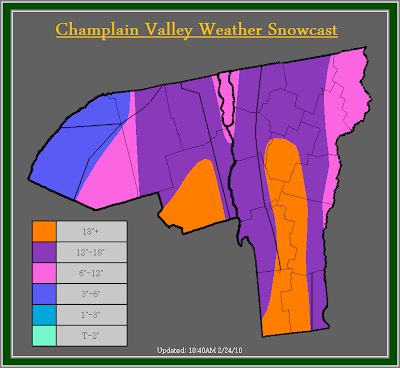
         Looking at water vapor imagery, and IR satelite you can see the plume of moisture continuing to be advected back into our region. A dry slot is also evident across central New York, and down across Southern New England. Due to current snow accumulations, and radar trends, I have increased snow totals once again. Much of the area can expect 12-18 inches, with 6-12 across far Northeastern Vermont, and in the immediate Champlain Valley mainly, north of Burlington. Across the St. Lawrence valley, now that more reports have came in, they don't have as much as I originally though, therefor they are in the 3-6 inch range now. I will keep them in the warning even though its strongly against the criteria, only because the snow is extremely wet and heavy, and numerous power outages have been reported. It does not take much of this heavy wet snow to bring down tree limbs.

         Looking at the Champlain Valley Weather Alerts map, you notice a Winter Storm Warning in effect for the current storm, and also a Blizzard Watch. I have issued a Blizzard watch for the next storm, which is set to hit our area Thursday into Friday Night. At this time the forecast remains tough as significant shadowing will likely occur across Northern Vermont, and temperature will probably warm up, but at this point I feel its safe to issue a Blizzard watch, as snow will fall across much of the area, how much though is hard to say. The highest amounts will be across Northern New York. Also the winds with this system look to gust up to around 60MPH at times in the higher elevations and 45-50MPH in the Valley's. Stay tuned for further updates.


The previous post is below...


Alert Details:
         The National Weather Service in Burlington has issued a Winter Storm Warning for much of Vermont, and Northern New York for heavy wet snow accumulations of 8-12 inches in the Champlain Valley, and Northern Vermont, with 12-20 inches in the Southern Green mountains, and the Eastern slopes of the Northern Adirondack mountains, with locally higher amounts in the higher elevations. They have also issued a Winter Weather Advisory for portions of the St. Lawrence Valley and the far Northeast Kingdom for heavy wet accumulations of snow ranging from 3-7 inches.

         The National Weather Service in Albany, NY has issued a Winter Storm Warning for extreme southern Vermont for 10-20 inches of snow.

       & Champlain Valley Weather has issued a Winter Storm Warning for all of Vermont for storm totals of greater then 18 inches in the eastern/ southeastern upslope areas of the Southern Green mountains. 12-18 inches can be expected across the western slopes of the green mountains and higher elevations with 6-12 inches in the Champlain Valley, and far Eastern Vermont. A Winter Storm warning is in effect for much of Northern New York except where greater then 18 inches is expected to accumulate along the eastern slopes of the Northern Adirondack mountains and 12-18 inches for the Northern Adirondack mountains, with 6-12 inches for the St. Lawrence Valley.


Champlain Valley Weather Discussion:
         Snow totals outside of the Champlain Valley have surprised me a little bit. Shadowing along the western slopes of the green mountains has been non existent, already many places along the western slopes of the greens are reporting 8-10 inches with locally higher amounts of up to 11-12 inches in places such as Richford, Berkshire, and Jericho. Areas in the immediate Champlain Valley are reporting 4-7 inches with locally higher amounts to around 9 inches in places such as Williston. With all this said, accumulations by this morning have exceeded my expectations, and a Winter Storm Warning has been required for everyone.

         So far the snow as expected has been very wet and heavy, much heavier then I expected. Already numerous power outages have started to occur, and over 9,300 people are without power in the State of Vermont alone. Snow ratios are as low as 5.5:1 that means 5.5 inches of snow to 1 inches of liquid. To compare that, the average snow ratio across our region during the winter is around 12-15:1, meaning 12-15 inches of snow to 1 inch of liquid. Also, the roads have become treacherous, and if out on the roads use extreme caution, not only for slick roads, but the potential for falling trees. Stay tuned for further updates on this weather situation.

February 23, 2010

UPDATE: Heavy Snow/ Possible Power Outages

UPDATE AS OF 8:20PM...
         At this time everything appears to be on track. Rain or any rain/ snow mix has changed to mainly snow, and will continue to change over to mainly snow during the rest of the evening. Snow will likely become heavy at times during the day Wednesday. Total snow accumulations remain unchanged, and the alerts do as well. The previous post has been copied and pasted below. Stay tuned for further updates.


Alert Details:
         The National Weather Service in Burlington has issued a Winter Storm Warning for much of Vermont, and Northern New York for heavy wet snow accumulations of 12-18 inches in the Northern Adirondack Mountains, 8-14 inches across South Central Vermont, 4-10 inches across North Central and portions of Northeast Vermont, and 4-8 inches for the entire Champlain Valley. They have also issued a Winter Weather Advisory for portions of the St. Lawrence Valley and the far Northeast Kingdom for heavy wet accumulations of snow ranging from 2-6 inches.

         The National Weather Service in Albany, NY has issued a Winter Storm Warning for extreme southern Vermont for the potential of 8-16 inches of snow.

       & Champlain Valley Weather has issued a Winter Storm Warning for the Northern Adirondack Mountains, and portions of Central and Southern Vermont for 12-16 inches of snow with isolated amounts exceeding 16 inches across the highest of elevations, and favored upslope regions lower elevations in these areas will see 8-12 inches. A Winter Weather Advisory is in effect for the St. Lawrence Valley, the Champlain Valley, and much of Northern Vermont for 4-8 inches of heavy wet snow.

Champlain Valley Weather Discussion:
         Weather models are finally starting to agree somewhat upon a solution, especially for this first part of the storm. While small differences still remain, I feel confident enough to issue Winter Storm Warnings and Winter Weather Advisories for the area.

         I will admit I was having a hard time deciding whether or not to issue a Warning or Advisory for the areas receiving 4-8 inches. The reason being, this event is going to be around 24 hours long, and criteria to issue a Warning is 6 or more inches of snow within 12 hours or 8 or more inches of snow within 24 hours. Going strictly by that criteria an Advisory was issued, but I was contemplating the possibility of a Warning due to the fact the snow is going to be extremely wet and heavy, and has a good possibility of producing some power outages. At this time though I will hold off on a Warning, but I want you to be aware that the Advisory may be changed to a Warning depending on how this storm evolves. One more point I would like to make about this heavy wet snow, is all areas will have the potential for some power outages. Across the Warning area this will be even more important as the higher accumulations of very wet and heavy snow could cause some roof collapses, especially where 12 or more inches fall. Places that could experience roof collapses would be poorly constructed sheds or barns. With this storm it will be important to keep the snow cleared off your roofs.

         As for this portions of the long durations storm, you can expect a snow/ rain mix to develop across the region late this afternoon and spread from south to north. Snow will become heavy at times overnight tonight, and snowfall rates could reach 1-2 inches per hour for a time on Wednesday. Snowfall intensities like this will result in visibility under a half to quarter mile at times, and result in rapid accumulations. If you must travel tomorrow, use cautions and stay updated on this developing winter storm.

         Before I finish this post I am going to brush upon the next significant portions of this storm, which will be a low pressure system for Thursday into Friday night. This low pressure system will likely make this current system look small. This is because the next storm is not only going to effect a larger area of the Northeastern united states, but its going to have the potential to produce Blizzard conditions. A few models are indicating this potential such as the GFS which strengthens the low to 976mb over NYC, the RSM 976 over Albany, the NAM 980mb over NYC, and the WRF model 986mb over Rhode Island. That's just a few. The only thing with this, as the storm retrogrades back to the above mentioned areas at their above mentioned strength then this may cause warm air to push into our region, especially Northern areas. If that were to occur then more rain might be the result, also strong winds may cause significant shadowing across much of Northern Vermont. At this time though we will deal with the upcoming portions of this complex storm, and go from there. Stay tuned for further updates.

February 15, 2010

UPDATE: Snow For Tuesday


Champlain Valley Weather Discussion:
         I had to make some big changes, based on current radar, and model trends. Low pressure is currently trying to develop off the coast of New Jersey, unfortunately this low is not going to gather as much strength or moisture as originally thought. Also the upslope aspect of the storm may not be as significant either, but that will continue to be monitored and addressed by tomorrow night.

         As far as alerts go, I have cancelled the Winter Weather Advisory for Northern and Central Vermont, and have downgraded the Winter Storm Warning to a Winter Weather Advisory for 3-6 inches by Tuesday night. The National Weather Service in Burlington, Vermont continues a Winter Weather Advisory for Rutland, Windsor, and Orange Counties for the potential of 3-5 inches of snow, and the National Weather Service in Albany, New York continues a Winter Storm Watch for Bennington, and Windham Counties for the potential of 7+ inches of snow.

January 25, 2010

UPDATE 6: Flooding Continues Across The Region


Current Alert Details:
         The National Weather Service in Burlington, Vermont has issued a Flood Warning for the East Branch of the Ausable River, in Clinton County New York due to an icejam. A Flood Watch remains in effect through Tuesday morning.

         The National Weather Service in Albany, New York has issued a Flood Warning for the Walloomsac River, and the Batten Kill in Bennington County due to rapid rises on these two rivers. The Flood Watch remains in effect and now extends until 7AM Tuesday morning.

         Champlain Valley Weather has issued a Flood Warning for the East Branch of the Ausable River in Clinton County New York. A Flood Warning for the Walloomsac River, and the Batten Kill in Bennington County. A Flood Warning for the Otter Creek in Rutland County, and A Flood Advisory for Grandisle, Franklin, Orleans, Essex, Chittenden, Lamoille, Caledonia, Addison, Washington, Orange, Windsor, and Windham Counties in Vermont, and Essex County in Northern New York due to significant nuisance flooding.

Champlain Valley Weather Discussion:
         See the National Weather Service's website Burlington Area Office or if in Bennington, and Windham Counties Albany Area Office for details on the flood warnings for the Walloomsac River, Batten Kill, and East Branch of the Ausable River.

         Champlain Valley Weather has issued a Flood Warning for the Otter Creek at Center Rutland. Currently the Otter Creek at Center Rutland is at a stage of 7.02 feet. Flood Stage is 8.0 Feet. The Otter Creek will continue to rise steadily and crest at 9.0 feet by 7AM Tuesday Morning.

         Champlain Valley Weather continues the Flood Advisory for the above mentioned counties due to significant rainfall. This rainfall combined with snowmelt, has resulted in significant rises on area waterways. Many small creeks and streams are out of their banks, with significant field flooding. For the most part flooding should remain minor. If traveling use extreme caution, and do not travel over a flooded road.

         While the rain and wind has settled down, the water continues to rise, although numerous waterways have crested or are getting ready to crest within the next several hour. Some of the large stem river will crest later tomorrow morning. There has been signs of ice jams on several of the large stem rivers such as the Missisquoi, Lamoille, and Winooski Rivers. Currently these rivers are remaining below flood. The only river right now that has icejam flooding of any sort is the East Branch of the Ausable River.

         Conditions will continue to be monitored for further icejam flooding. Stay tuned to Champlain Valley Weather and your local weather, and media outlets for further updates. This should be one of the final updates on this storm system.