Showing posts with label Wind. Show all posts

December 18, 2011

Another Round of Strong Winds On Tap For Tomorrow


Alerts:
CPV Weather
         -Champlain Valley Weather has issued a Wind Advisory for portions of the Northern and Central Champlain Valley, and the St. Lawrence Valley in New York for sustained winds of 15-30MPH with gusts up to 50MPH. The Wind Advisory is in effect from 3AM Monday morning through 3PM Monday afternoon.

--------------------------------------------------------------------------------

National Weather Service:
         -The National Weather Service in Burlington, VT has not issued any alerts at this time.

         -The National Weather Service in Albany, NY has not issued any alerts at this time.

--------------------------------------------------------------------------------

Champlain Valley Weather Discussion:
         Another low pressure system moving north of the region is expected to bring some light precipitation, and strong winds to the region, tomorrow.

         Currently, winds and temperatures are rising across much of the region. In the Champlain Valley temperatures have risen 3-6 degrees in the past hour. Winds have also gone from calm or light and variable to sustained 5-15MPH with gusts ranging from 10-20MPH. Winds will markedly increase over the next few hours and peak out tomorrow late-morning/ early afternoon. At the peak of the strong winds, speeds will range from 20-30MPH with gusts to 50MPH. Over the open waters of Lake Champlain, winds could be slightly stronger. In fact, right now winds over Lake Champlain are mixing nearly 100% down to the surface from 5000 feet above the surface, mainly due to the warm lake waters helping the winds mix down. So, as always in these events slightly stronger winds are likely over the open waters of the lake, and near the immediate lake shore. These areas could see winds at their peak range from 25-40MPH with isolated gusts to 55MPH.

         For the St. Lawrence Valley of New York, Southwest winds of 15-30MPH with occasional gusts of 45-50MPH are possible. The strongest winds in this area will likely be from Ogdensburg to Malone. Stay tuned for further updates on this developing weather situation.

December 14, 2011

Wintry Mix & Strong To Damaging Winds Possible


Alerts:
CPV Weather
         -Champlain Valley Weather has issued a High Wind Watch for the Champlain Valley of Vermont, and New York for potential of strong to damaging winds of 25-40MPH with gusts 55-60MPH. The Watch is in effect from 11PM tonight until 6PM Thursday.

         -Champlain Valley Weather has issued a Winter Weather Advisory for the Northern Adirondack mountains in Northern New York, and much of Vermont, except the Champlain Valley and Western Rutland County for a Wintry mix of precipitation, with up to two tenths of an inch of ice accumulation. The Advisory is in effect from 10PM this evening until 10AM Thursday morning.

--------------------------------------------------------------------------------

National Weather Service:
         -The National Weather Service in Burlington, VT has not issued any alerts at this time.

         -The National Weather Service in Albany, NY has issued a Winter Weather Advisory for Bennington, and Windham Counties in Southern VT for wintry mix, and light glaze of ice. The Advisory is in effect from 10PM tonight until 6AM Thursday.

--------------------------------------------------------------------------------


Champlain Valley Weather Discussion:
         A significant storm system to impact the region later tonight into tomorrow, as a low pressure system strengthens from the Great Lakes region up into Canada. At this point it appears that the onset of precipitation will occur tonight resulting in cool temperatures to start, and light snow and/ or sleet should start nearly everywhere. The wintry precipitation will rapidly change over to rain though in the Champlain, and St. Lawrence Valleys, but the higher elevations, and especially the sheltered valley's will see the wintry precipitation last the longest, where it will change over to a period of freezing rain. Some of the most sheltered valley's in the Advisory area could see light freezing rain last until around 10AM tomorrow morning. This will result in up to 1 inch of snow, and up to two tenths of an inch of ice by 10AM tomorrow morning.

         As the strengthening storm system moves northeast from the Great Lakes, and into Canada a strong low level jet will develop resulting in strong southerly winds across the area. Nearly everyone will see wind gusts over 30MPH, however strong winds will occur in the St. Lawrence Valley and potentially damaging winds will occur in the Champlain Valley. At this point it appears the St. Lawrence Valley will see winds of 15-25MPH with gusts 45-50MPH. The same winds are likely in the Southern Champlain Valley as well. Across the Central, and especially Northern Champlain Valley though, winds will likely be stronger, and potentially damaging. Winds are expected to be in the 25-40MPH range with gusts 50 to 60MPH. The strongest winds will likely be closest to the lake shore, and over Grand Isle County. Over the open waters of Lake Champlain winds will be even stronger in the 40-50MPH range with gusts up to 65MPH. This will result in large battering waves on the open waters of Lake Champlain. There is still some question as to whether or not any rain will stabilize the surface layer and prevent the winds from mixing down to the surface, so at this point a High Wind Watch is in effect. It does appear likely that High Wind Warnings, and Wind Advisories will likely be issued later tonight, once a little more weather model data becomes available. Stay tuned for updates on this developing weather situation.

February 14, 2011

UPDATE: Near Blizzard Conditions Across The Region

Alerts:
CPV Weather
         (UPDATED) -Champlain Valley Weather has updated the Winter Weather Advisory which has been expanded to now cover the entire Champlain Valley, the entire Western slopes region of the Green mountains, and the Western slopes of the Northern Adirondack mountains for snow accumulations of 3-6 inches, and significant blowing and drifting snow. The Advisory is in effect until 2AM tomorrow morning.

         -Champlain Valley Weather has issued a Wind Chill Warning for much of Vermont, and Northern New York excluding the Champlain and St. Lawrence Valley's, and far southern Vermont. Wind chill reading will be in the 25 to 35 below zero range overnight. The Warning is in effect until 12PM tomorrow.

         -Champlain Valley Weather has issued a Wind Chill Advisory for the Champlain and St. Lawrence Valley's and far Southern Vermont for wind chills in the 15 to 25 below zero range overnight. The Advisory is in effect until 12PM tomorrow.

         -Champlain Valley Weather has issued a Wind Advisory for all of Vermont, and Northern New York for sustained winds of 15-30MPH with wind gusts in the 40-50MPH range overnight. The Advisory is in effect until 8AM tomorrow.

--------------------------------------------------------------------------------

National Weather Service:
         -The National Weather Service in Burlington, VT has issued a Wind Chill Advisorty for much of Vermont and Northern New York except the Champlain and St. Lawrence Valley's. Wind chill reading are expected to be as low as 30 below zero. The Advisory is in effect until 10AM tomorrow.

         -The National Weather Service in Albany, NY has issued a High Wind Warning for Western Windham County in Southern Vermont. Sustained winds of 20-40MPH with gusts of 50-65MPH are likely overnight. The Warning is in effect until 10AM tomorrow.

-The National Weather Service in Albany, NY has issued a Wind Advisory for Bennington, and eastern Windham Counties in Southern Vermont. Sustained winds of 20-30MPH with gusts of 45-55MPH are likely overnight. The Advisory is in effect until 10AM tomorrow.

--------------------------------------------------------------------------------


Champlain Valley Weather Discussion:
         I had to do an update to reflect the fact that strong upslope, and Champlain Valley convergence has set up. Snow moderate to heavy at times will coninue for the next hour or so, before diminishing in intensity, and tappering off around 2AM. Snow accumulations will range from 3-6 inches in the Advisory area. You can also expect significant blowing and drifitng snow, with near blizzard conditions at times.

         Everything else remains on track as far as wind chills and strong winds go, so check the previous post for details on that. Also want to apologize for no updated maps, I am unable to work on the maps at this time, so text only. Stay tuned for any further updates.

Snow, Wind, and Dangerously Cold Wind Chills


Alerts:
CPV Weather
         -Champlain Valley Weather has issued a Wind Chill Warning for much of Vermont, and Northern New York excluding the Champlain and St. Lawrence Valley's, and far southern Vermont. Wind chill reading will be in the 25 to 35 below zero range overnight. The Warning is in effect until 12PM tomorrow.

         -Champlain Valley Weather has issued a Winter Weather Advisory for the western slopes of the Northern Adirondack mountains, and the western slopes of the far northern green mountains in Vermont for snow accumulations of 2-5 inches with blowing and drifting. The Advisory is in effect until 11PM tonight.

         -Champlain Valley Weather has issued a Wind Chill Advisory for the Champlain and St. Lawrence Valley's and far Southern Vermont for wind chills in the 15 to 25 below zero range overnight. The Advisory is in effect until 12PM tomorrow.

         -Champlain Valley Weather has issued a Wind Advisory for all of Vermont, and Northern New York for sustained winds of 15-30MPH with wind gusts in the 40-50MPH range overnight. The Advisory is in effect until 8AM tomorrow.

--------------------------------------------------------------------------------

National Weather Service:
         -The National Weather Service in Burlington, VT has issued a Wind Chill Advisorty for much of Vermont and Northern New York except the Champlain and St. Lawrence Valley's. Wind chill reading are expected to be as low as 30 below zero. The Advisory is in effect until 10AM tomorrow.

         -The National Weather Service in Albany, NY has issued a High Wind Warning for Western Windham County in Southern Vermont. Sustained winds of 20-40MPH with gusts of 50-65MPH are likely overnight. The Warning is in effect until 10AM tomorrow.

-The National Weather Service in Albany, NY has issued a Wind Advisory for Bennington, and eastern Windham Counties in Southern Vermont. Sustained winds of 20-30MPH with gusts of 45-55MPH are likely overnight. The Advisory is in effect until 10AM tomorrow.

--------------------------------------------------------------------------------


Champlain Valley Weather Discussion:
         A low pressure system moving off to the Northeast will strengthen a bit, with a strong high pressure moving in from the west. This will result in a tight pressure gradient, falling temperatures, and even some accumulation snow.

         Already the cold front has shifted across all of Northern New York, and much of Northwestern Vermont with snow squalls, rapidly falling temperatures, and strong winds. If you have yet to encounter the cold front, that is what you can expect. Behind the cold front, temperatures will continue to plummet, and winds will continue to increase, resulting in strong winds, and cold wind chills overnight. Also some accumulating snow can be expected across much of the region, but the most snow will accumulate in upslope areas of the Northern Adirondacks and Northern Green mountains into this evening. The snow should tapper off overnight as much colder and drier air punches into the region. Stay tuned for any further updates.

December 27, 2010

UPDATE: Blowing Snow & Cold Windchill Into Tomorrow


Alerts:
CPV Weather
         -Champlain Valley Weather has issued a Winter Weather Advisory for the entire Champlain Valley, and all of Vermont for Blowing Snow, Cold Wind Chills, and Light Snow, with additional accumulations of a Trace to 3 inches. The Winter Weather Advisory is in effect until 11PM tonight.

--------------------------------------------------------------------------------

NWS Albany, NY:
         -The National Weather Service in Albany NY, has issued a Winter Weather Advisory for Bennington, and Windham Counties in Southern Vermont for Blowing Snow.

         -The National Weather Service in Albany, NY has issued a Wind Chill Advisory for Bennington and Western Windham County in Vermont for dangerous wind chills down to 20 below zero tonight.

--------------------------------------------------------------------------------


Champlain Valley Weather Discussion:

OVERVIEW
         A strong low pressure center continues to slow move to the Northeast and will eventually end up in the Canadian Maritimes later today. A Tight pressure gradient, is resulting in blowing and drifting of snow, and cold wind chills.

WIND & WINDCHILL
         The biggest concern left with this storm is the strong winds, and the associated wind chills. Winds will continue to be sustained in the 10-20MPH range with isolated gusts up to 30MPH area wide today into tomorrow. This will result in Wind chills today in the 5 above zero to 10 below zero range today, area wide. The warmer readings if you want to call it that, will be in the Champlain Valley, and the colder readings in the higher elevations. Tonight the Winter Weather Advisory will likely be cancelled and a Wind Chill Advisories/ Warnings will likely be put in place for much of the area. Wind chills tonight will be in the 10 below zero to 20 below zero range for the Champlain Valley, and for the higher elevations wind chill values will be in the 15 below zero to 30 below zero range. Make sure if you venture out today, and especially tonight, you bundle up and stay very warm, as it wont take long for frostbite to occur with wind chills this low.

SNOWFALL & BLOWING SNOW
       &nbsb Snowfall for today has pretty much ended, except some light to occasionaly moderate snow showers across the Northern Half of Vermont, and far Northeastern New York. Additional snowfall accumulations today should be a Trace to 1 inch in the immediate Champlain Valley, to as much as 1-3 inches in the more persistent and heavier snow showers towards the Western slopes of the Green mountains.

         The next concern, especially for today is the blowing and drifting of the snow. Strong winds mentioned above in the Wind chill section, will also produce some areas of blowing and drifting snow. The blowing and drifting should slowly become less intense as the snow that's being blown around begins to settle due to not much additional fresh snow. The Winter Weather Advisory is in effect to highlight all the aspects ongoing right now, from the Blowing and drifting of the snow, to the cold wind chills, and the light additional snow accumulations. Travel will be rather difficult today and this evening, so use extreme caution. The Advisory will likely be dropped later tonight and a Wind Chill Advisory/ Warning will likely take over at that time. Stay tuned for further updates.

December 11, 2010

Another Storm Storm System To Impact The Region Sunday Into Monday


Alerts:
CPV Weather:
         -Champlain Valley Weather has issued a High Wind Warning for the Western slopes of the Green mountains in Vermont for winds in the 20-40MPH range with gusts ranging from 65-75MPH, especially in favored areas such as Richford, Bakersfield, Cambridge, Jericho, Huninton, and Rutland.

         -Champlain Valley Weather has issued a High Wind Warning for the Northern Adirondack Mountains in New York for winds in the 15-35MPH range with gusts ranging from 55-65MPH. All Warnings are in effect from 8AM Sunday morning until 8PM Sunday night.

         -Champlain Valley Weather has issued a Wind Advisory for the Champlain Valley, and Western Rutland County in Vermont for winds in the 15-25MPH range with gusts in the 45-55MPH range. The Highest gusts will occur across areas closes to the Western slopes of the Green mountains.

--------------------------------------------------------------------------------

NWS Burlington, VT:
         -The National Weather Service in Burlington, VT has issued a High Wind Watch for the Western Slopes of the Green mountains, and Western Rutland County for winds in the 20-35MPH range with gusts up to 60MPH.

         -The National Weather Service in Burlington, VT has issued a High Wind Watch for the Northern Adirondack Mountains in New York, for winds in the 20-30MPH range with gusts up to 55MPH. The watches are in effect from Sunday Morning through Sunday Night.

--------------------------------------------------------------------------------

NWS Albany, NY:
         -The National Weather Service in Albany, NY has issued a High Wind Watch for Bennington, and Western Windham Counties in Vermont for winds in the 20-40MPH range with gusts in the 50-60MPH range. The Watch is in effect from Sunday Morning through Monday Morning.

--------------------------------------------------------------------------------


Champlain Valley Weather Discussion:

OVERVIEW
         Low pressure over the Great Lake region will continue to move Northeast towards the St. Lawrence River Valley. A new low pressure system is expected to form near North Carolina, and move Northward over Western Vermont. This will result in primarily strong winds and rain.

WIND
         Winds will be the primary concern with this storm, especially along the Western slopes of the Green mountains. At this point winds shouldn't be quite as strong as they were on the Dec. 1st storm, but still gusts in excess of 65MPH is likely across the favored downslope areas. Isolated gusts to 75MPH could be possible. Max wind gusts in the Dec. 1st storm were in the 80-90MPH range, so this time around it will be damaging but not quite as bad. Conditions will continue to be monitored closely.

PRECIPITATION
         This system will start of with a mix of Snow/Sleet/Freezing Rain, and change over to all rain Sunday afternoon. Precipitation will change back to some snow by late Monday. By then most of the precipitation will be out of the region. Rain totals will range from a half inch in downslope areas to around 1 inch in the favored upslope areas. No flooding is expected. Stay tuned for further updates on this developing storm system.

November 22, 2010

Strong Winds In The Champlain Valley Today


Alerts:
CPV Weather
         -Champlain Valley Weather has issued a Wind Advisory for the entire Champlain Valley until 6PM tonight for sustained winds of 15-30MPH, with gusts in the 40-50MPH range.

--------------------------------------------------------------------------------

Champlain Valley Weather Discussion:

OVERVIEW
         Low pressure west of the region is pressing up against High pressure off the Atlantic Coast which is resulting in a strong pressure gradient. Winds from the south are channeling through the Champlain Valley resulting in strong winds.

WIND
         Today you can expect strong south winds of 15-30MPH with gusts as high as 50MPH especially the closer to Lake Champlain you get. South or North winds are often strongest in the Champlain Valley as the winds are Channeled through the valley. The pressure gradient should ease some later this evening. I will post a small list of some of the higher sustained winds and wind gusts across the region already this morning.

MEASURED SUSTAINED WINDS
Colchester Reef: 41MPH
Swanton Town: 32MPH
South Burlington: 23MPH
Swanton Village: 21MPH
Highgate: 21MPH
Grand Isle: 18MPH
Plattsburgh: 16MPH


MEASURED WIND GUSTS
Swanton Town: 51MPH
Colchester Reef: 45MPH
South Burlington: 39MPH
Swanton Village: 33MPH
Grand Isle: 31MPH
Highgate: 30MPH
Plattsburgh: 25MPH

November 17, 2010

Strong Winds To Impact The Region Overnight


Alerts:
CPV Weather
         -Champlain Valley Weather has issued a Wind Advisory for all of Northern New York, and All of Vermont for sustained winds of 15-30MPH, with gusts in the 40-50MPH range.

--------------------------------------------------------------------------------

NWS Burlington, VT
         -The National Weather Service in Burlington, VT has issued a Wind Advisory for all of Northern New York, and all of Vermont for sustained winds in the 20-35MPH range with gusts in the 46-50MPH range.

--------------------------------------------------------------------------------

NWS Albany, NY
         -The National Weather Service in Albany, NY has issued a Wind Advisory for Bennington, and Windham Counties in Southern Vermont for sustained winds in the 20-30MPH range with gusts up to 50MPH.

--------------------------------------------------------------------------------

Champlain Valley Weather Discussion:

OVERVIEW
         Low pressure currently North of the region is slowly strengthening resulting in a tight pressure gradient. The low pressure system should continue to move East-Northeast, and continue to bring strong winds to the region.

WIND
         The primary concern with the system is the wind. Much of the steady rain has moved North and East of the region with just some scattered showers left for this evening and overnight. A tight pressure gradient across our region is resulting in these strong winds. The winds will continue to strengthen this evening, and reach there peak overnight. Sustained winds will range from 15-30MPH with gusts in the 40-50MPH range. The highest gusts should be across the downslope areas of the Eastern slopes of the Adirondack mountains, and across the Southern Green mountains of Vermont. Winds of this magnitude have the potential to bring down weak trees, and tree limbs, resulting in scattered power outages.

PRECIPITATION
         The precipitation has pretty much ended with this storm. Some showers will be possible as winds turn to the Northwest and push any additional moisture into the mountains. The heaviest of showers will be combined to the Northwest upslope regions. A change from rain showers to snow showers is likely overnight. There is a slight chance of some snow flakes in the Champlain Valley if enough moisture is present by the time the temperatures drop. Stay tuned to Champlain Valley Weather for any further updates on this storm.

November 7, 2010

Coastal Storm To Bring Wintry Precipitation & Strong Winds


Alerts:
CPV Weather
         -Champlain Valley Weather has issued a Winter Weather Advisory for portions of Northern New York, most of Vermont, and the Northern Champlain Valley. For a mix of wintry precipitation, with snow/ sleet accumulations up to 1 inch, and ice accumulations of up to a tenth of an inch.

         -Champlain Valley Weather has issued A Wind Advisory for the entire Champlain Valley, the Eastern Adirondack, and the Western Slopes of the Green mountains. Sustained Northerly winds will be in the 15-30MPH range with gusts to 50MPH. Isolated strong wind gusts could occur along the Lake Champlain shoreline.

--------------------------------------------------------------------------------

NWS Burlington, VT
         -The National Weather Service in Burlington, VT has issued a Winter Weather Advisory for portions of the Adirondack Mountains, and much of Vermont excluding the Champlain Valley. For a mix of wintry precipitation with Snow/ sleet accumulations up to 1 inch, and a minor ice accumulation.

--------------------------------------------------------------------------------

NWS Albany, NY
         -The National Weather Service in Albany, NY has issued a Winter Weather Advisory for Bennington, and Windham Counties in Vermont. For a mix of wintry precipitation with snow/ sleet accumulations less then one inch, and Ice accumulations of up to a tenth of an inch.

--------------------------------------------------------------------------------

Champlain Valley Weather Discussion:

OVERVIEW
         A low pressure system developing well off the Coast will retrograde back west towards Cape Cod overnight into tomorrow morning. This will spread precipitation across our region late tonight into tomorrow. With cold air in place at the surface, precipitation will start of in the frozen form, eventually transitioning to all rain across the entire region.

WINTRY PRECIPITATION
         Precipitation in almost all locations should start in the frozen form, however most valley locations should switch over to all rain fairly early. The Frozen precipitation will hold on longer across the Northern Champlain Valley, and especially across the higher elevations, and mountain valleys across Vermont, and Northeastern New York. There is some concern though, with strong north winds, that cooler air could hold on longer then expected, resulting in more frozen precipitation for the entire area, including the entire Champlain Valley. At this point though, I will leave the Central, and Southern portions of the Champlain Valley out of the Winter Weather Advisory, and monitor conditions closely.

WIND
         With a tight pressure gradient setting up, and winds being from the North, the Champlain Valley and areas just to the east, and west of the Valley will experience some strong winds. Right now 925mb winds are expected to be 35-55 knots over the Champlain Valley, and adjacent areas. Winds should mix down the most right over Lake Champlain with wind gusts on the open lake up to 60MPH possible. Inland across the Advisory area though winds will be slightly less with sustained winds in the 15-30MPH range with gusts to 50MPH. Along the Lakeshore winds could be slightly higher. Areas not in a Wind Advisory will see winds in the 10-25MPH range with gusts 30-40MPH.

RAINFALL
         With recent moderate to heavy rainfall, and very saturated ground, it wouldn't take much additional rain to cause some flooding. At this point though liquid equivalent/ rainfall totals should range from a half inch in downslope areas of the Northeast Kingdom, to around 1 inch or slightly higher in the Champlain Valley due to favorable valley convergence with a strong Northerly flow. At this time only very minor flooding is possible, and not enough to warrant a flood watch. Should things change, then a Flood Watch may be needed. Stay tuned for further updates on this developing weather situation.

October 14, 2010

Major East Coast Storm To Bring Rain, Wind & Snow To Our Region


Alerts:
CPV Weather
         -Champlain Valley Weather has issued a Winter Weather Advisory for elevations of 1500 feet and higher in Orleans, Lamoille, Washington, Eastern Franklin, Eastern Chittenden, Eastern Addison, and Eastern Rutland Counties in Vermont, and Western Essex, Western Clinton, and Southern Franklin Counties in Northern New York for the potential of 2-6 inches of heavy wet snow.

         -Champlain Valley Weather has issued a Flood Watch for all of Vermont, and most of Northern New York, excluding St. Lawrence County for 1-3 inches of rain. Where the Winter Weather Advisory is in effect, the flood watch is in effect for those same counties, but primarily below 1500 feet, where mainly rain will fall.

         -Champlain Valley weather has issued a High Wind Watch for the Champlain Valley, and Rutland, and Bennington Counties in Vermont for the potential of strong to damaging winds. Sustained Northerly winds of 20-35MPH with localized gusts to 60MPH are possible, especially within the Champlain Valley, or on the South shore of Lake Champlain.

         -Champlain Valley Weather has issued A Wind Advisory is in effect for all the remainder of Vermont, and all of Northern New York for strong winds. Sustained Northerly winds will be in the 15-30MPH range with gusts to 50MPH.

--------------------------------------------------------------------------------
NWS Burlington, VT
         -The National Weather Service in Burlington, VT has issued a Flood Watch for portions of Northeastern New York, and For the all of Vermont excluding Grand Isle County, for the potential of 1-2 inches of rain, with localized amounts of up to 3 inches by Saturday.

--------------------------------------------------------------------------------
NWS Albany, NY
         -The National Weather Service in Albany, NY has issued a Flood Watch for Bennington, and Windham Counties in Vermont for the potential of 1-2 inches of rain with localized amounts of up to 3 inches.

         -The National Weather Service in Albany, NY has issued a Winter Storm Watch for elevations above 2000 feet, in Bennington, and Western Windham Counties in Vermont for the potential of 7 or more inches of snow by Saturday morning.

         -The National Weather Service in Albany, NY has issued a Wind Advisory for Bennington, and Windham Counties in Vermont for the potential of strong wind gusts up to 50MPH.

--------------------------------------------------------------------------------

Champlain Valley Weather Discussion:

OVERVIEW
         A strong, and dynamical storm is going to impact the region overnight tonight into early Saturday morning. A little bit of everything is expected with this storm, including heavy rain, strong winds, and heavy snow for elevations above 1500 feet.
         Currently a 1006mb low pressure system is located east of the delmarva peninsula, and moving Northeast. As this system continues to move Northeast it will rapidly intensify. Already 3hr pressure falls indicate its deepening at 3mb's in a 3 hour period, so 1mb an hour. Thats pretty decent, however later tonight and tomorrow, even more rapid intensification is likely. All models are in agreement bringing this storm down into the 980-984mb range, which is a very strong system.

RAINFALL
         Rain should continue to develop across the region overnight tonight, and become heavy at times after midnight. Rain will continue heavy at times across much of Vermont, for friday. There could also be some enhanced heavy rainfall for an extended period of time over the Champlain Valley, as significant Champlain Valley Convergence sets up, with a strong northerly flow. Rain totals across the entire area should range from 1-3 inches, some localized amounts near 4 inches is not completely out of the question at this time. The least amount of rain will be across the St. Lawrence Valley of New York, and the heaviest should be along the spine of the Green mountains. If the heavier amounts are witnessed then flooding will likely be an issue. Right now though only minor/ nuisance flooding is possible. The ground is still fairly saturated from the rains we had in late September.

WIND
         The wind concern is a bit more difficult to forecast with high confidence as many factors are pushing towards strong winds, but a couple strong factors are against it. First off as this system rapidly intensifies the pressure gradient is going to tighten fast. Winds just above the surface will be howling at 40-60 knots, however cool rain, and cool temperatures at the surface may help prevent winds from mixing down to the surface. Now, with this in mind we have another factor to look at, which is the direction of the wind. The wind is expected to be coming from the north, and with the Champlain Valley, being a North-South oriented Valley, means that a South or North wind is funneled through the valley making winds stronger. So it may not take much mixing down of the wind to the surface for it to become gusty, especially in the Champlain Valley. Thats why I have issued a High Wind Watch for the Champlain Valley, and Rutland and Bennington Counties, as Winds could be into the 20-35MPH range with isolated gusts to 60MPH, especially the closer to the lakeshore you get. If this become more immenent then a High Wind Warning may be needed, if the winds appear to be lighter then a Wind Advisory will be issued instead. And just that, a Wind Advisory is what in effect for the rest of the region as winds should mix down enough everywhere for gusts to occasionaly reach 50MPH, especially across exposed terrain.

SNOWFALL
         This is going to be the most difficult part of the storm to predict. There is so much against it, and so much for it happening. First off the time of year is not the greatest to get significant snowfall across the area, but yes it does happen, especially in the higher elevations. Models dont agree at all on this situation, some models are showing absolutly no snow, and other are showing 6-12, and some are showing up to 20 inches of snow (for the highest of elevations of course)!!! Now due to the fact of this rapidly intensifing low pressure system being off the coast, and a 500mb cutoff overhead or very close by, the dynamical cooling alone should be absolutly impressive, and even with some models showing snow down to 2500 feet, I feel that the pure dynamics of this storm are going to give us some suprises, and I will side closer with the NAM model as far as where areas of snow are likely. I dont agree on how much the NAM model is showing however, so I have cut back significantly on the snow amounts on that model. I feel that 2-6 inches is strongly possible for areas above 1500 feet, with the lower amounts being near 1500 feet, and the higher amounts being towards the highest summits, and this is why I issued a Winter Weather Advisory for certain counties. In all honesty, I would not be surpised if some places above 3500 feet (which there is not many of) see snow totals around 10 inches. I wouldnt be suprised to see some wet snowflakes mix in even below 1500 feet, in fact I personally dont feel its out of the question for areas in the Valley away from lake Champlain to see some wet snowflakes mix in with the rain late friday evening/ night into Saturday morning. The reasoning behind that, once again is the strong north wind causing significant convergence in the valley resulting in the potential of some very dynamically heavy rain, which could push some cooler air even closer to the surface than currently expected. One thing I will say, is that absolutly no accumulation will occur in the Valley if some snowflakes were to mix in. It would still be primarily rain, and this would only occur for a very brief period of time. Stay tuned for further updates on this developing situation.

October 11, 2010

Potential Winter Weather Event Thursday To Saturday


Champlain Valley Weather Discussion:
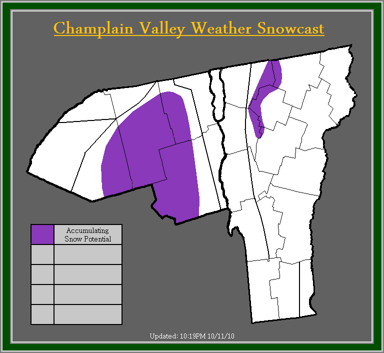
         Suprisingly, models are coming into agreement on what could be out first semi-winter weather event. Models are showing a low pressure system forming along the mid-Atlantic coast, intensifying and moving up the coast to around Cape cod. This is where models diverge, some track it inland over southern and Central New England, others trend it over Cape Cod, and some models move the low pressure system to the east of Cape Cod. Also all models vary in strength. Some showing a sub 985mb low pressure system, while others show a sub 995mb, low pressure system. Neither is too shabby but the sub 985mb were to come true, we could be seeing an interesting scenario setting up.

         Currently I will play it middle of the road, and forecast mainly rain with some higher elevation snow showers especially in the Northern Adirondacks for the time being. The ultimate track and strength of this system is key to if, when, and how much snow will fall. At this point those living in elevations above 2000 feet should pay close attention to future forecasts. Those below 2000 feet, don't let your guard down quite yet, as those of us in Central and Northern Vermont, and Northeastern New York can easily remember the snowstorm back on April 28th of this year. I do want to urge that I am not saying this system is similar, but just remind those that the weather is very unpredictable. Also winds could be a factor with this upcoming storm system, stay tuned to Champlain Valley Weather for further updates on this potential situation.

September 30, 2010

UPDATE: Flooding Rains & Strong Winds Into The Overnight


Alert Details:
         The National Weather Service in Burlington, VT continues the Flood Watch for all of Vermont and Northern New York for the potential of 3-4 inches of rain with locally higher amounts by early Friday morning.

         The National Weather Service in Albany, NY continues the Flood Watch for Bennington, and Windham Counties in Vermont for 2-6 inches of rain with locally higher amounts possible by early Friday morning. A High Wind Warning is also in effect for the potential of damaging wind gusts up to 60MPH, with localized gusts in excess of 60MPH.

         Champlain Valley Weather continues a Wind Advisory for All of Vermont, and portions of Northeastern New York, for sustained winds of 15-30MPH with gusts to 50MPH. Winds will increase later this evening, and tapper off by Friday mid-morning. Depending on the overall strength and track of the system, winds could potential be stronger and a High Wind Warning may be needed with short notice. A Flood Watch also continues for all of Northern New York, and Vermont for the potential of 2-4 inches of rain with isolated amounts exceeding 4 inches. Stay tuned for further updates.

Champlain Valley Weather Discussion:
         Just an update, everything appears to be on track. Still concerned with rainfall totals, some models are indicating 1-3 inches some 2-4 inches, and some 3-5+ inches. At this point I will stick with the 2-4. The best chance at seeing in excess of 4 inches of rain will be across the Adirondacks of Northern New York, and across Southern, and portions of Eastern Vermont. Already as little as a quarter inch to as much as 2 inches of rain has fallen across the area, with the lowest amounts in the St. Lawrence and Champlain Valley's, and the highest amounts across Southeastern Vermont. For the rest of today the heaviest rain should be over Northern New York, and the heavy rain threat will shift back into Vermont into this evening and overnight.

         As far as winds go, the surface has been extremely stable, and winds have been calm almost the entire day. Winds are going to highly dependent on the ultimate track of the low pressure center, and whether or not we can get the warm front to move over our area. If the warm front moves overhead, then the surface will become more unstable allowing for stronger winds. Right now, we will have to wait and see what happens, but I am fairly confident that we will see some stronger wind gusts, especially in the higher elevations. A High Wind Warning still may be needed upon short notice overnight, especially for areas in Southern Vermont. Please stay tuned for further updates on this developing weather situation.

September 29, 2010

Potential Flooding Rainfall & Strong Winds For Thursday and Thursday Night


Alert Details:
         The National Weather Service in Burlington, VT has issued a Flood Watch for all of Vermont and Northern New York for the potential of 3-4 inches of rain with locally higher amounts by early Friday morning.

         The National Weather Service in Albany, NY has issued a Flood Watch for Bennington, and Windham Counties in Vermont for 2-6 inches of rain with locally higher amounts possible by early Friday morning. A High Wind Watch is also in effect for the potential of strong to damaging wind gusts in excess of 60MPH.

         Champlain Valley Weather has issued a Wind Advisory for All of Vermont, and portions of Northeastern New York, for sustained winds of 15-30MPH with gusts to 50MPH. Isolated gusts to 55MPH are possible in areas most vulnerable to south winds in the higher elevations. Winds will increase Thursday afternoon, and tapper off by Friday morning. Depending on the overall strength and track of the system, winds could potential be stronger and a High Wind Warning may be needed with short notice. A Flood Watch is also in effect for all of Northern New York, and Vermont for the potential of 2-4 inches of rain with isolated amounts exceeding 4 inches in favored upslope regions in the extreme eastern Adirondacks, and southern portions of Vermont. This amounts of rain, will likely lead to minor to moderate flooding. If widespread 4"+ amounts occur, then significant flooding may occur. Rain will be heaviest during Thursday afternoon, into Thursday night. Stay tuned for further updates.

Champlain Valley Weather Discussion:
         A significant storm system is set to impact the area, including the remnants of former Tropical Storm Nicole. A series of low pressure waves will ride up along a stalled front across our region Early Thursday morning through Thursday night. Due to its origins being from the tropics, a tropical airmass will be overhead and result in significant rainfall. At this time I am forecasting 2-4 inches with as little as 2 inches in the Champlain Valley to as much as 4 or more inches across upslope region of the Adirondacks, and across portions of Southern Vermont. Still a bit concerned that numerous models are indicated the potential for a widespread rainfall in excess of 4 inches across portions of the area, but I am hoping it is just convective feedback on the models, which does happen often. I am concerned though, because even 3 or 4 inches of rain will likely result in widespread minor to possibly moderate flooding. This will have to be watched very closely.

         The next concern with this system is wind. The pressure gradient is expected to tighten up significantly, especially the further south you go. Generally a South wind spells trouble for the Champlain Valley, but due to the track of the low pressure centers being fairly close/ almost overhead of the Champlain Valley, they may be relieved of some very strong winds. Not to mention that the lower levels may end up being a bit to stable due to the rain, for the winds to mix down from further up in the atmosphere. At this point though, I feel a Wind advisory is needed. If the storm tracks are slightly further to the west, and/ or near the surface is a bit more unstable, then stronger winds could occur. This will be closely monitored. Stay tuned for further updates on this developing situation.

April 27, 2010

Late Season Winter Storm To Bring Significant Snowfall Accumulations


Alert Details:
         The National Weather Service in Burlington, VT has issued a Winter Storm Warning for North-Central Vermont, and Northeast Vermont, including the Western Slopes of the Green Mountains for snow totals ranging from 8-14 inches with locally higher amounts along the western slopes of the far Northern Green Mountains. A Winter Storm Warning is also in effect for the Northern Adirondack mountains for snow totals of 8-14 inches. A Winter Weather Advisory is in effect for the Northern St. Lawrence Valley of New York, and the remainder of Vermont for 3-7 inches of snow.

         The National Weather Service in Albany, NY has issued a Winter Weather Advisory for Bennington, and Windham Counties in Vermont for 3-6 inches of snow.

         Champlain Valley Weather has issued a Winter Storm Warning for portions of Northern and Central Vermont for 6-12 inches of snow, with 12-18 inches of snow across the Western Slopes of the Green mountains. A Winter Storm Warning is in effect for the Northern Adirondack Mountains for 6-12 inches of snow. A Winter Weather Advisory is in effect for the Western Champlain Valley, and Southern Champlain Valley, and portions of South-Central Vermont, and Northwestern New York for 3-6 inches of snow.

Champlain Valley Weather Discussion:
         A late season winter storm is impacting the region right now, with significant snowfall in excess of 6 inches already being reported in eastern Chittenden, and Eastern Franklin Counties. Here in the Champlain Valley, snow totals have ranged from a Trace to 3 inches. As with Early Season or Late Season Winter Storms, snow totals will be highly elevation dependent. Snow intensities across much of the region are ranging from moderate to occasionally heavy, and this should continue overnight tonight and into early Wednesday Morning. The heaviest snow will fall across the Northern Green mountains of Vermont, especially the Western Slopes, where a favorable upslope flow will enhance snow intensities for much of the storm.

         Due to the fact this snow is of a heavy wet nature, and tree's are already beginning to leaf in some areas, it wont take much for tree limbs to come down, and result in power outages. Right now around 277 people are without power, but that number will likely climb the remainder of the day, and overnight tonight. Winds will also be increasing and gusting up to 30MPH later tonight. For now roads remain wet, with some snowy patches on secondary roads, this should remain the case into this evening. Once the sun sets though, and temperatures drop below the freezing mark, snow will begin to accumulate on the roads. By tomorrow morning roads will be snow covered and will likely be very slick. Make sure to use extreme caution while out traveling. Stay tuned to Champlain Valley Weather for any further updates on this developing Winter Storm.

February 24, 2010

Major East Coast Storm To Bring Blizzard Conditions


Alert Details:
         The National Weather Service in Burlington has issued a Winter Storm Warning for much of Vermont, excluding the Champlain Valley, the Warning also covers Northern New York, excluding the Champlain and St. Lawrence Valley's. The Winter storm warning is in effect for the potential of 6-12 inches of snow, with wind gusts up to 50MPH. The Winter storm warning for the previous storm still remains in effect for all the same areas as earlier.

       & Champlain Valley Weather has issued a Blizzard Warning for much of Vermont, and Northern New York, for 6-12 inches of snow, with sustained winds of 20-30MPH with gusts in the 50-55MPH range. A Blizzard Watch remains in effect for the Champlain Valley, and the extreme southern Connecticut River Valley in Vermont, for the potential of 3-6 inches of more of Snow accumulation combined with strong winds in the 15-25MPH with gusts in the 45-50MPH range.


Champlain Valley Weather Discussion:
         As we get done one storm, we start another. This storm has been extremely hard to forecast, and the potential of busting on this is moderate. There are so many aspects to this storm to figure in to consideration, its tough. Infact there has been no winter storm like this, as far as track and strength go, in the past 30 years to compare it too. The National Weather Service did a search on the CIPS analog system, and there were no matches for the past 30 years. While yes, I am sure there has been a storm similar to this since records began, there is no detailed data to help with the forecast. Therefor, we are going into somewhat uncharted territory.

         Now while there is no winter storm comparison for this type of track and strength of a storm in recent years, we can still look back to a few things for help. The storm position will result in a easterly wind across the area. As we know, with an easterly flow, the mountains block (shadow) precipitation from the Valley's, so areas such as the Champlain Valley, and the Connecticut River Valley, tend to be warmer, and drier, but the eastern slopes of the green mountains tend to be cooler and wetter, due to upslope dynamics. We also know easterly winds tend to funnel through the mountain gaps and produce very strong to damaging winds, along east facing slopes, but of most significance the western slopes of the green mountains.

         Now with the above known, temperature problems still exist, with a storm track such as this, warm air will wrap up and around the east side and over towards the north. This will likely bring in warm Atlantic moisture, which could result in warm valley temperatures and not much snow, especially if significant downsloping occurs, which is very possible. But to complicate the matter more, winds may have just enough of a Northerly component across the Champlain Valley, that temps could remain cooler, and the downsloping would not be as pronounced.

         So at this time, this is what I am thinking, rain/snow mix will develop tonight and become potentially heavy tomorrow late afternoon or early evening. By Friday afternoon, total snow accumulations look at this current moment, 6-12 inches for the higher elevations, and 3-6 inches in the valley locations. For the Champlain Valley its tough, at this point I am calling for 3-6 inches, but if a northerly wind component can establish itself, and have good effect then we may end up with more snow. If there is not much of a northerly wind component, then we may see much less then 3-6 inches. With that said, the Valley locations remain under a Watch, while the Higher elevations are under a Warning. With these being Blizzard alerts, that means yes, winds will be a factor. Winds of 20-30MPH with gusts in the 50-55MPH range can be expected across the higher elevations, and western slopes especially. The Valley locations will see sustained winds of 15-25MPH with gusts in the 45-50MPH range. This will cause significant blowing and drifting of snow, especially across the higher elevations. As things become more certain, then a Blizzard Warning or Winter Weather Advisory will be issued for the Champlain Valley, and Southern Connecticut River Valley. Stay tuned for further updates on this developing weather situation.

January 24, 2010

UPDATE: Heavy Rain & Strong Winds Tonight Into Monday


Current Alert Details:
         The National Weather Service in Burlington, VT continues a Flood Watch for much of Vermont, and portions of Northern New York for the potential of flooding from heavy rains, and the potential for ice jam flooding due to expected rapid rises on area waterways. They also have issued A Wind Advisory, which is in effect for the Western slopes of the Green mountains for Southeast winds of 25-35MPH with gusts up to 50MPH possible after midnight tonight.

         The National Weather Service in Albany, NY continues a Flash Flood Watch for extreme Southern Vermont for the potential of flash flooding due to heavy rains, and possible ice jam flooding due to significant rises on area waterways.

         Champlain Valley Weather continues a Flood Watch for much of Vermont, and portions of Northern New York for the potential of a widespread 1-2 inches of rain, with locally higher amounts, which will lead to potential flooding, and significant rises on area waterways, which will also produce great risk of ice jam flooding. A High Wind Warning now replaces the previous High Wind Watch, for the Western slopes of the Green mountains for the potential of strong southeast winds of 25-40MPH with gusts up to 60MPH, with isolated higher gusts in most favored mountain gap locations.


Champlain Valley Weather Discussion:
         A significant storm system, will begin to impact the region later this evening, with strong to potentially damaging winds, moderate to heavy rain, and potential flooding on Monday.

         Currently, a 984mb low pressure system over Northeastern Wisconsin, will continue to move North-Northeast today, and this evening. Out ahead of this system a strong, and moist southerly flow upon a tightening pressure gradient will continue to result in temperatures rising, moisture pushing into our area, and winds to increase.

         Heavy rain and the flood potential is the primary concern with this system. Rain will develop later this evening, and become heavy at times after midnight. Rain will continue heavy at times through Monday morning, and begin to diminish in intensity Monday afternoon. Rainfall totals are depicted on the map at the top of this post, so please make sure to check that out. The heaviest rain still appears to be across Central, and Southern Vermont. Its not out of the question for isolated amounts in excess of 3-4 inches to occur, especially across the Southeast upslope areas of the Central, and Southern Green mountains. This amount of rain combined with snowmelt, from temperatures being in the 40's to near 50 Monday, will result in rapid rises on area waterways.

         With the ground being frozen the rainfall, and snow melt will flow directly into area waterways, and not be absorbed by the ground at all, which is very significant. I was thinking about following the National Weather Service in Albany, NY and issue a Flash Flood Watch for everyone, but a large question remains as to how much the current snowpack will be able to absorb and hold the rain. In the Champlain, and St. Lawrence Valley's there is around 4-9 inches of snow. The snowpack across these places wont be able to absorb the rain as the snowpack is not that great. Across the higher terrain though especially about 1000 feet, snowpack of 12+ inches remains. These areas will be able to hold the rain better, but with warmer temperatures the past week or so, with slight melting everyday, and the expected warmer temperatures today, and Monday the snowpack may be ripe, and if it is, then rapid snowmelt will occur as well in the higher elevations. But its not knowing, which is holding me off from a Flash Flood Watch.

         Eitherway, rapid rises on area waterways will occur, and with the rivers rising, and a solid sheet of ice across them, this ice will become unstable and begin to break. This will result in a significant ice jam threat, and their associated flooding risks. So overall I feel a flood watch is the safe bet, and we will remain with that.

         Right now the pressure gradient is tight, but no where as tight as what it will be later tonight or tomorrow morning. Already we are seeing a primarily southerly wind, which is being enhanced in the Champlain Valley resulting in sustained winds in the 10-20MPH range, with gusts in the 25-35MPH range. Earlier a wind gust of 41MPH was recorded at the National Weather Service office in Burlington, Vermont. The 41MPH wind gust appears to be a more localized stronger gust, and remains shy of the 46MPH gust criteria for a Wind Advisory. These winds will continue to be monitored, but at this point I am not going to issue a Wind Advisory, and you will likely not see one issued for the National Weather Service for the Champlain Valley either.

         As the winds slowly shift to a more southeasterly direction things will become more interesting overnight, especially along the western slopes of the Green mountains, where the National Weather Service has issued a Wind Advisory. I feel winds are going to be stronger then anticipated and I have issued a High Wind Warning. I feel there will be a time period long enough for High Wind Warning type winds to occur before the heaviest rain moves in to stabilize the lower layer of the atmosphere. Even then I feel damaging wind gusts will be able to mix down and funnel through the favorable mountain gaps, and passes of the Western slopes of the Green mountains. Therefor in areas such as Richford, Bakersfield, Cambridge, Jericho, Huntington, Appalachian Gap, Rutland, and Bennington, winds will increase into the 25-40MPH range by late tonight, with gusts in the 60MPH range. Some of these gusts will be able to accelerate better through some of the mountain gaps, and isolated wind gusts to 70MPH are possible in the most favorable gap locations. The strongest winds should occur prior to the heaviest rainfall, but even after the heaviest rain moves in, isolated damaging wind gusts will likely continue, but be less often, and likely be well under 70MPH. The strong to damaging winds should start to diminish later Monday afternoon.

         The last concern is the potential for some light icing at the onset of precipitation tonight, especially across the sheltered valley's of eastern Vermont, and the extreme Northern St. Lawrence Valley of New York. The National Weather Service in Burlington has issued a Freezing Rain Advisory for the Northeast Kingdom and Eastern Vermont for the potential of up to a tenth inch of ice accumulation. I am holding off on issuing a Freezing rain advisory, while I feel the areas that receive ice accumulation in eastern Vermont will be very isolated. Also I feel if any area has a greater threat of seeing icing, it would be the extreme Northern St. Lawrence Valley, where winds remain out of the northeast, and the temperatures are still below freezing. The atmosphere is also very dry, and as the precipitation tries to fall through the atmosphere it will result in evaporative cooling, which will help lower temperatures a couple degrees area wide. So places currently hovering around freezing will likely fall below freezing, resulting in some sleet/ freezing rain. I will continue to monitor this potential, for the possibility of issuing a Freezing Rain Advisory for the Northern St. Lawrence Valley, and perhaps portions of eastern Vermont. Stay tuned to Champlain Valley Weather, and your locally weather and media outlets for further information on this upcoming storm system. I will try to have another update later this evening.

January 23, 2010

Flooding Rains & Strong Winds Possible For Sunday Into Monday


Champlain Valley Weather Discussion:
         The National Weather Service in Burlington, VT has issued a Flood Watch for much of Vermont, and portions of Northern New York for the potential of flooding from heavy rains, and the potential for ice jam flooding due to expected rapid rises on area waterways.

         The National Weather Service in Albany, NY has issued a Flash Flood Watch for extreme Southern Vermont for the potential of flash flooding due to heavy rains, and possible ice jam flooding due to significant rises on area waterways.

         Champlain Valley Weather has issued a Flood Watch for much of Vermont, and portions of Northern New York for the potential of 1-2 inches of rain with locally higher amounts, which will lead to potential flooding, and significant rises on area waterways, which will also produce great risk of ice jam flooding. A High Wind Watch has also been issued for the Western slopes of the Green mountains for the potential of strong southeast winds of 25-40MPH with gusts up to 60MPH, with isolated higher gusts in most favored mountain gap locations.

         Currently a low pressure system is expected to move into the Midwestern portion of the United States, and push significant amounts of moisture, and warmer air into the region.

         Rain showers should develop Sunday afternoon, and overspread the entire region by Sunday evening. Rain will become steady overnight, and become heavy at times through Monday afternoon. Widespread rainfall totals of 1-2 inches, with locally higher amounts to near 4 inches are possible by Monday afternoon. The highest amounts are likely to occur across Central, and Southern Vermont. This amount of rain combined with temperatures in the mid 40's to lower 50's, will produce significant snowmelt, and runoff into are waterways. The result will be significant rises on area waterways, and potential flooding. Along with normal flooding concerns, the rapid rises will likely break up river ice and result in ice jams, which could enhance flooding significantly. If you live near an area waterway, it is urged to monitor it closely, and at any signs of flooding, move to higher ground immediately.

         Rain wont be the only problem with this storm system, winds will also be a concern. Especially along the western slopes of the green mountains. Southeast winds across the entire region will average 15-25MPH with isolated gusts up to 40MPH. For the favored gap locations along the western slopes of the green mountains such as Cambridge, Huntington, and Rutland winds will likely be in the 25-40MPH range with gusts up to 60MPH, isolated gusts up to 70MPH are possible in the most favored mountain gap locations. Winds of this magnitude would result in tree damage, and power outages as well as isolated structural damage. The strongest winds will occur late Sunday Night into Monday afternoon. Stay tuned for further updates on this developing storm system.

January 3, 2010

Massive Winter Storm Winding Down


Champlain Valley Weather Discussion:
         The National Weather Service in Burlington continues a Winter Storm Warning for the region for 1-2 feet of snow, with 6-12 inches across Northeastern Vermont, and Northern New York.

         Champlain Valley Weather Suggested Alerts, have changed to a Winter Storm Warning, the Blizzard Warning has been cancelled. I have made this change due to the fact that winds have diminished some. While winds will still be fairly strong, they will not be meeting that 35MPH criteria anymore, NEAR Blizzard conditions are likely throughout the day though. Snow totals remain the same as in the previous post, so read the previous forecast for my snow totals, or just look at the map above.

         Of interesting note is that South Burlington, Vermont, at the National Weather Service Office, there has been 26 inches of snow as of 7AM. This is actually more snow then reported so far along the western slopes of the green mountains. This is quite impressive.

         Snow should continue through the day, but overall lighten up, and become more showery in nature. There is the potential for another round of moderate snow later this afternoon before going back to more showery type light snow. Places such as Burlington may receive 30 or more inches of snow by the time this storm completely winds down by Monday morning. Stay tuned for any further updates.

December 31, 2009

Potential New Years Weekend Blizzard


Champlain Valley Weather Discussion:
         A very tough system to forecast, remains just that. Tough. But models appear to be coming back into some type of agreement on the potential for a Blizzard across our area. Luckily, the brunt of the storm will occur after New Years day.

         Since I want to emphasize on this storm, I am going to refrain from a meteorological discussion, so this post does not end up too long. So with that in mind, what is expected to happen, is several pieces of energy are going to come together, out over the Atlantic ocean, and as this system rapidly strengthens, it will run into upper atmosphere blocking, which will allow this system to have a very rare track. This system while pushing towards Nova Scotia will, slow considerable, and begin to retrograde (move against the normal flow of the atmosphere) moving west-south west, and down into the Gulf of Maine.

         Before this system gets cut off from the jet stream, and being to retrograde, models have this system deepening into a very intense system. Models are showing this system to range from 960-970mb. The pressure equates to that of Cat. 2 - 3 Hurricane. The last time there was a low pressure system to effect the Northeast, with pressure into the 960's, was the 1993 Superstorm, which deepened down to 961mb. While this system is going to be very strong, it will be nothing like the 1993 Superstorm, as far as the widespread effects go. For areas, especially in Maine, this will likely be a storm to remember for quite some time.

         Anyway, as this system spins up into the 960-970mb range, and cuts off from the jet stream it will slowly retrograde into the gulf of Maine, and slowly weaken as it does so. Never the less, tremendous amounts of moisture will stream across Maine, New Hampshire, New York, and Vermont. While last nights models were indicating that precipitation would be light from Tonight into Monday, they have now started to trend back to slightly heavier amounts of precipitation across our area.

         What to expect across our region, is snow slowly developing overnight tonight, and remaining light to occasionally moderate until Saturday night. Snow accumulations from Tonight through Saturday Night will range from 2-6 inches. Winds should begin to increase into the 10-20MPH range with gusts to 30MPH Saturday afternoon. Winds will continue to increase into Saturday Night.

         For Saturday Night into Monday morning, snow intensities should increase, and snow will be falling moderate to occasionally heavy at times. Winds will increase into the 20-30MPH range with gusts in the 40-45MPH range. This will result in considerable, blowing and drifting snow. Along with temperature falling into the mid teens to lower 20's, for Saturday night into Sunday night, wind chills will range from the single digits above zero to the single digits below zero. Snow accumulation for the Saturday night into Monday morning time frame will range from 8-12 inches. This will result in Total snowfall accumulations for the entire event ranging from 10-18 inches. With localized amounts up to 2 feet along the western slopes of the Green mountains, near areas such as Jay Peak. Snow intensities and winds should begin to weaken Monday morning. I would like to urge, that as the main portion of the event (Saturday Night to Monday Morning) approaches, additional adjustments to snowfall accumulations will be likely.

         With the above information noted, I have issued a Blizzard Watch for the entire region, for Saturday Night into Sunday Morning. Due to the potential of significant snowfall accumulations combined with strong winds, and cold wind chills. I have not issued any alerts for the Tonight through Saturday Night time frame, as snow totals are marginal for a Winter Weather Advisory, especially over such an extended period of time. Stay tuned for further updates.

         I also would like to mention that at this time there are no OFFICIAL alerts in effect from the National Weather Service.