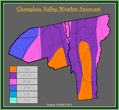


Suprisingly, the snow has piled up very nicely across the entire region, with the exception of the St. Lawrence Valley. Power outages continue to add up across the region and over 16,000 people are without power in the state of Vermont alone.
Looking at water vapor imagery, and IR satelite you can see the plume of moisture continuing to be advected back into our region. A dry slot is also evident across central New York, and down across Southern New England. Due to current snow accumulations, and radar trends, I have increased snow totals once again. Much of the area can expect 12-18 inches, with 6-12 across far Northeastern Vermont, and in the immediate Champlain Valley mainly, north of Burlington. Across the St. Lawrence valley, now that more reports have came in, they don't have as much as I originally though, therefor they are in the 3-6 inch range now. I will keep them in the warning even though its strongly against the criteria, only because the snow is extremely wet and heavy, and numerous power outages have been reported. It does not take much of this heavy wet snow to bring down tree limbs.
Looking at the Champlain Valley Weather Alerts map, you notice a Winter Storm Warning in effect for the current storm, and also a Blizzard Watch. I have issued a Blizzard watch for the next storm, which is set to hit our area Thursday into Friday Night. At this time the forecast remains tough as significant shadowing will likely occur across Northern Vermont, and temperature will probably warm up, but at this point I feel its safe to issue a Blizzard watch, as snow will fall across much of the area, how much though is hard to say. The highest amounts will be across Northern New York. Also the winds with this system look to gust up to around 60MPH at times in the higher elevations and 45-50MPH in the Valley's. Stay tuned for further updates.
The previous post is below...
Alert Details:
The National Weather Service in Burlington has issued a Winter Storm Warning for much of Vermont, and Northern New York for heavy wet snow accumulations of 8-12 inches in the Champlain Valley, and Northern Vermont, with 12-20 inches in the Southern Green mountains, and the Eastern slopes of the Northern Adirondack mountains, with locally higher amounts in the higher elevations. They have also issued a Winter Weather Advisory for portions of the St. Lawrence Valley and the far Northeast Kingdom for heavy wet accumulations of snow ranging from 3-7 inches.
The National Weather Service in Albany, NY has issued a Winter Storm Warning for extreme southern Vermont for 10-20 inches of snow.
& Champlain Valley Weather has issued a Winter Storm Warning for all of Vermont for storm totals of greater then 18 inches in the eastern/ southeastern upslope areas of the Southern Green mountains. 12-18 inches can be expected across the western slopes of the green mountains and higher elevations with 6-12 inches in the Champlain Valley, and far Eastern Vermont. A Winter Storm warning is in effect for much of Northern New York except where greater then 18 inches is expected to accumulate along the eastern slopes of the Northern Adirondack mountains and 12-18 inches for the Northern Adirondack mountains, with 6-12 inches for the St. Lawrence Valley.
Champlain Valley Weather Discussion:
Snow totals outside of the Champlain Valley have surprised me a little bit. Shadowing along the western slopes of the green mountains has been non existent, already many places along the western slopes of the greens are reporting 8-10 inches with locally higher amounts of up to 11-12 inches in places such as Richford, Berkshire, and Jericho. Areas in the immediate Champlain Valley are reporting 4-7 inches with locally higher amounts to around 9 inches in places such as Williston. With all this said, accumulations by this morning have exceeded my expectations, and a Winter Storm Warning has been required for everyone.
So far the snow as expected has been very wet and heavy, much heavier then I expected. Already numerous power outages have started to occur, and over 9,300 people are without power in the State of Vermont alone. Snow ratios are as low as 5.5:1 that means 5.5 inches of snow to 1 inches of liquid. To compare that, the average snow ratio across our region during the winter is around 12-15:1, meaning 12-15 inches of snow to 1 inch of liquid. Also, the roads have become treacherous, and if out on the roads use extreme caution, not only for slick roads, but the potential for falling trees. Stay tuned for further updates on this weather situation.

No comments:
Post a Comment